
Boffa topographic map
Interactive map
Click on the map to display elevation.
About this map
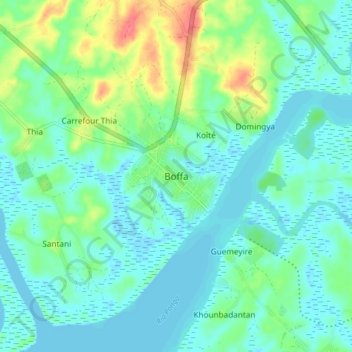
Name: Boffa topographic map, elevation, terrain.
Location: Boffa, Boké Region, Guinea (10.14123 -14.07770 10.22123 -13.99770)
Average elevation: 46 ft
Minimum elevation: -13 ft
Maximum elevation: 184 ft
Other topographic maps
Click on a map to view its topography, its elevation and its terrain.
Gaoual Prefecture
Gaoual Prefecture, Boké Region, Guinea
Average elevation: 899 ft
Koundara Prefecture
Koundara Prefecture, Boké Region, Guinea
Average elevation: 407 ft