
Fria topographic map
Interactive map
Click on the map to display elevation.
About this map
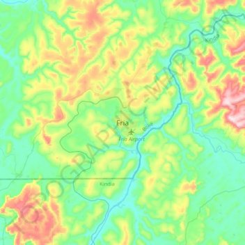
Name: Fria topographic map, elevation, terrain.
Location: Fria, Boké Region, Guinea (10.20304 -13.74119 10.52304 -13.42119)
Average elevation: 515 ft
Minimum elevation: 36 ft
Maximum elevation: 1,693 ft
Other topographic maps
Click on a map to view its topography, its elevation and its terrain.
Gaoual Prefecture
Gaoual Prefecture, Boké Region, Guinea
Average elevation: 899 ft
Koundara Prefecture
Koundara Prefecture, Boké Region, Guinea
Average elevation: 407 ft