
Koundara Prefecture topographic map
Interactive map
Click on the map to display elevation.
About this map
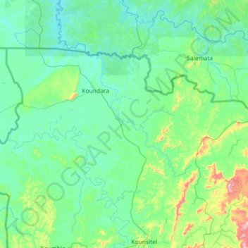
Name: Koundara Prefecture topographic map, elevation, terrain.
Location: Koundara Prefecture, Boké Region, Guinea (11.99441 -13.70954 12.67563 -12.56850)
Average elevation: 407 ft
Minimum elevation: 72 ft
Maximum elevation: 3,245 ft
Other topographic maps
Click on a map to view its topography, its elevation and its terrain.