
Make a donation
Gear up for your next adventure:
As an Amazon Associate, this site earns from qualifying purchases at no extra cost to you.
Cheruthuruthy topographic map
Click on the map to display elevation.
Make a donation
Gear up for your next adventure:
As an Amazon Associate, this site earns from qualifying purchases at no extra cost to you.
About this map
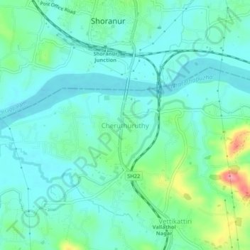
Name: Cheruthuruthy topographic map, elevation, terrain.
Location: Cheruthuruthy, Talappilly, Thrissur, Kerala, 679123, India (10.72696 76.25512 10.76696 76.29512)
Average elevation: 121 ft
Minimum elevation: 43 ft
Maximum elevation: 397 ft
Make a donation
Gear up for your next adventure:
As an Amazon Associate, this site earns from qualifying purchases at no extra cost to you.
Other topographic maps
Click on a map to view its topography, its elevation and its terrain.
Sreekumar,Kalathil Veedu, Kumbalangad Vaka Kulam 2
India > Kerala > Talappilly
Average elevation: 128 ft
Make a donation
Gear up for your next adventure:
As an Amazon Associate, this site earns from qualifying purchases at no extra cost to you.
Make a donation
Gear up for your next adventure:
As an Amazon Associate, this site earns from qualifying purchases at no extra cost to you.