
Make a donation
Gear up for your next adventure:
As an Amazon Associate, this site earns from qualifying purchases at no extra cost to you.
Hermaringen topographic map
Click on the map to display elevation.
Make a donation
Gear up for your next adventure:
As an Amazon Associate, this site earns from qualifying purchases at no extra cost to you.
About this map
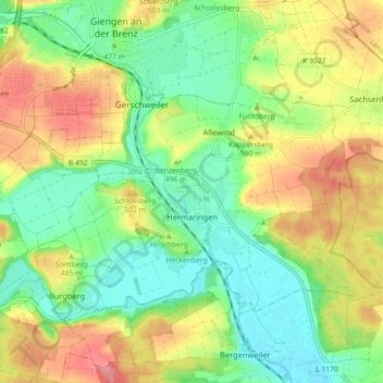
Name: Hermaringen topographic map, elevation, terrain.
Average elevation: 1,578 ft
Minimum elevation: 1,450 ft
Maximum elevation: 1,752 ft
Make a donation
Gear up for your next adventure:
As an Amazon Associate, this site earns from qualifying purchases at no extra cost to you.
Other topographic maps
Click on a map to view its topography, its elevation and its terrain.
Heldenfingen
Deutschland > Baden-Württemberg > Landkreis Heidenheim > Heldenfingen
Average elevation: 1,909 ft
Schnaitheim
Deutschland > Baden-Württemberg > Landkreis Heidenheim > Heidenheim an der Brenz
Das Wohngebiet Mittelrain ist auf einer Anhöhe südwestlich vom Ortskern Schnaitheim gelegen und entstand zwischen den späten 1960er und frühen 1980er Jahren. Es ist verkehrstechnisch durch die Mittelrainstraße erschlossen, die das Gebiet nordöstlich umschließt und mit Schnaitheim im Osten und der Zanger…
Average elevation: 1,808 ft
Make a donation
Gear up for your next adventure:
As an Amazon Associate, this site earns from qualifying purchases at no extra cost to you.
Ugenhof
Deutschland > Baden-Württemberg > Landkreis Heidenheim > Herbrechtingen
Average elevation: 1,903 ft
Sontheim im Stubental
Deutschland > Baden-Württemberg > Landkreis Heidenheim
Average elevation: 1,867 ft
Birkelhöhle
Deutschland > Baden-Württemberg > Landkreis Heidenheim > Heidenheim an der Brenz
Average elevation: 1,877 ft
Make a donation
Gear up for your next adventure:
As an Amazon Associate, this site earns from qualifying purchases at no extra cost to you.
Lixenfeld
Deutschland > Baden-Württemberg > Landkreis Heidenheim > Herbrechtingen
Average elevation: 1,903 ft
Oggenhausen
Deutschland > Baden-Württemberg > Landkreis Heidenheim > Heidenheim an der Brenz
Average elevation: 1,877 ft
Make a donation
Gear up for your next adventure:
As an Amazon Associate, this site earns from qualifying purchases at no extra cost to you.
Plon
Deutschland > Baden-Württemberg > Landkreis Heidenheim > Sontheim an der Brenz
Average elevation: 1,453 ft
Rotensohl
Deutschland > Baden-Württemberg > Landkreis Heidenheim > Heidenheim an der Brenz > Großkuchen
Average elevation: 1,962 ft