
Make a donation
Gear up for your next adventure:
As an Amazon Associate, this site earns from qualifying purchases at no extra cost to you.
Mount Woodroffe topographic map
Click on the map to display elevation.
Make a donation
Gear up for your next adventure:
As an Amazon Associate, this site earns from qualifying purchases at no extra cost to you.
About this map
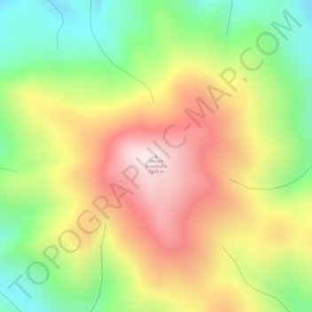
Name: Mount Woodroffe topographic map, elevation, terrain.
Average elevation: 3,786 ft
Minimum elevation: 2,802 ft
Maximum elevation: 4,715 ft
Make a donation
Gear up for your next adventure:
As an Amazon Associate, this site earns from qualifying purchases at no extra cost to you.
Other topographic maps
Click on a map to view its topography, its elevation and its terrain.
Pukatja
Australia > South Australia > Anangu Pitjantjatjara Yankunytjatjara
Average elevation: 2,408 ft
Watarru
Australia > South Australia > Anangu Pitjantjatjara Yankunytjatjara
Average elevation: 2,008 ft
Make a donation
Gear up for your next adventure:
As an Amazon Associate, this site earns from qualifying purchases at no extra cost to you.
Pukatja
Australia > South Australia > Anangu Pitjantjatjara Yankunytjatjara
Average elevation: 2,408 ft