Geolocate

Mersham topographic map

Click on the map to display elevation.

About this map

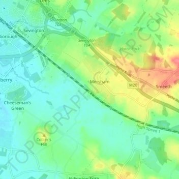
Name: Mersham topographic map, elevation, terrain.

Location: Mersham, Ashford, Kent, England, United Kingdom (51.09322 0.89336 51.14144 0.94954)

Average elevation: 180 ft

Minimum elevation: 115 ft

Maximum elevation: 318 ft

Other topographic maps

Click on a map to view its topography, its elevation and its terrain.

Potters Corner

United Kingdom > England > Kent > Ashford

Average elevation: 200 ft

Wye Downs

United Kingdom > England > Kent > Ashford

Average elevation: 387 ft

Small Hythe

United Kingdom > England > Kent > Ashford

Average elevation: 85 ft

Great Chart

United Kingdom > England > Kent > Ashford

Average elevation: 161 ft

Aldington Frith

United Kingdom > England > Kent > Ashford

Average elevation: 144 ft

St Michaels

United Kingdom > England > Kent > Ashford

Average elevation: 135 ft

Stonestreet Green

United Kingdom > England > Kent > Ashford > Aldington

Average elevation: 187 ft

Standen

United Kingdom > England > Kent > Ashford > Biddenden

Average elevation: 125 ft

Flip Out

United Kingdom > England > Kent > Ashford

Average elevation: 141 ft

Hassell Street

United Kingdom > England > Kent > Ashford > Hastingleigh

Average elevation: 440 ft

Hamstreet

United Kingdom > England > Kent > Ashford

Average elevation: 72 ft

Pluckley Thorne

United Kingdom > England > Kent > Ashford > Pluckley

Average elevation: 174 ft

Old Wives Lees

United Kingdom > England > Kent > Ashford

Average elevation: 217 ft

Wye

United Kingdom > England > Kent > Ashford

Average elevation: 180 ft

Boughton Lees

United Kingdom > England > Kent > Ashford

Average elevation: 259 ft

Stone Abbage

United Kingdom > England > Kent > Ashford

Average elevation: 154 ft

Cheeseman's Green

United Kingdom > England > Kent > Ashford

Average elevation: 144 ft

Stubbs Cross

United Kingdom > England > Kent > Ashford

Average elevation: 141 ft

Egerton Forstal

United Kingdom > England > Kent > Ashford

Average elevation: 164 ft

Stonebridge Green

United Kingdom > England > Kent > Ashford > Egerton

Average elevation: 262 ft

Hinxhill

United Kingdom > England > Kent > Ashford

Average elevation: 167 ft

Gear up for your next adventure:

🧣Hiking Neck Gaiter - Multi‑use neck protection for outdoor weather
🎒Hydration Pack - Hands‑free water reservoir for long hikes
🧭Compass with Lanyard - Easy‑carry compass for navigation
🦶Carbon Trekking Poles - Reduce knee impact on steep descents with ultra-light poles
🥇GPS Hiking Watch - Multi‑sport GPS watch with navigation and trail tracking

As an Amazon Associate, this site earns from qualifying purchases at no extra cost to you.