Geolocate

Aatchaneh topographic map

Click on the map to display elevation.

About this map

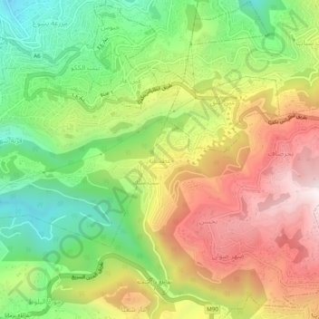
Name: Aatchaneh topographic map, elevation, terrain.

Location: Aatchaneh, Matn District, Mount Lebanon Governorate, 1207, Lebanon (33.89275 35.62927 33.93275 35.66927)

Average elevation: 2,201 ft

Minimum elevation: 922 ft

Maximum elevation: 3,684 ft

Other topographic maps

Click on a map to view its topography, its elevation and its terrain.

Beirut River

Lebanon > Mount Lebanon Governorate

During the Stone Age, the land on which Beirut is now built was two islands in the delta of the Beirut River, but over the centuries the river silted up and the two islands were connected into one land mass. The right bank of the Beirut River, southwest of the mountain resort town of Beit Mery at an altitude…

Average elevation: 2,047 ft

Ras El Metn

Lebanon > Mount Lebanon Governorate

Average elevation: 2,208 ft

Baabdat

Lebanon > Mount Lebanon Governorate

Average elevation: 2,657 ft

Aintoura

Lebanon > Mount Lebanon Governorate

Average elevation: 4,629 ft

Jal El Dib

Lebanon > Mount Lebanon Governorate

Average elevation: 253 ft

Sawfar

Lebanon > Mount Lebanon Governorate

Average elevation: 3,688 ft

Dbayeh

Lebanon > Mount Lebanon Governorate

Average elevation: 141 ft

Gear up for your next adventure:

🪶LED Camping Lantern - Bright lantern for camp lighting
🪶Thermal Camp Blanket - Extra warmth for cold nights
🥇GPS Hiking Watch - Multi‑sport GPS watch with navigation and trail tracking
🗺️Topographic Maps - Detailed topo maps for hiking, exploring and outdoor navigation
❄️Traction Cleats - Prevent slips on icy trails during winter hikes

As an Amazon Associate, this site earns from qualifying purchases at no extra cost to you.