
Make a donation
Gear up for your next adventure:
As an Amazon Associate, this site earns from qualifying purchases at no extra cost to you.
Diktel topographic map
Click on the map to display elevation.
Make a donation
Gear up for your next adventure:
As an Amazon Associate, this site earns from qualifying purchases at no extra cost to you.
Diktel
Diktel was renamed to Rupakot Majhuwagadhi on 10 March 2017 after merging some more VDCs. The municipality is divided into 15 wards. It is on 700 m to 2250 m of elevation from sea level. The area of the municipality is 246.51 km2. There are 10,050 households with population of 46,903. By 2020, the name commonly used name Diktel was re-added to the municipality's official name.
Make a donation
Gear up for your next adventure:
As an Amazon Associate, this site earns from qualifying purchases at no extra cost to you.
About this map
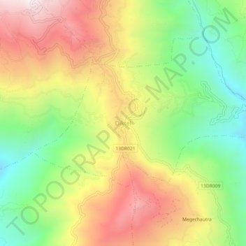
Name: Diktel topographic map, elevation, terrain.
Location: Diktel, Rupakot Majhuwagadhi, Khotang, Koshi Province, Nepal (27.19328 86.77318 27.23328 86.81318)
Average elevation: 4,895 ft
Minimum elevation: 3,389 ft
Maximum elevation: 6,601 ft
Make a donation
Gear up for your next adventure:
As an Amazon Associate, this site earns from qualifying purchases at no extra cost to you.
Other topographic maps
Click on a map to view its topography, its elevation and its terrain.