
Make a donation
Gear up for your next adventure:
As an Amazon Associate, this site earns from qualifying purchases at no extra cost to you.
Bethlehem topographic map
Click on the map to display elevation.
Make a donation
Gear up for your next adventure:
As an Amazon Associate, this site earns from qualifying purchases at no extra cost to you.
Bethlehem
According to the United States Census Bureau, the village has a total area of 3.54 square miles (9.17 km2), all land, at an elevation of 1,243 feet (379 m).
Make a donation
Gear up for your next adventure:
As an Amazon Associate, this site earns from qualifying purchases at no extra cost to you.
About this map
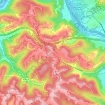
Name: Bethlehem topographic map, elevation, terrain.
Location: Bethlehem, Ohio County, West Virginia, United States (40.02863 -80.71363 40.06254 -80.66667)
Average elevation: 1,043 ft
Minimum elevation: 646 ft
Maximum elevation: 1,312 ft
Ohio County trails, hiking, mountain biking, running and outdoor activities
Make a donation
Gear up for your next adventure:
As an Amazon Associate, this site earns from qualifying purchases at no extra cost to you.
Other topographic maps
Click on a map to view its topography, its elevation and its terrain.
Pleasant Valley
United States > West Virginia > Ohio County > Wheeling > Pleasant Valley
Average elevation: 932 ft
Make a donation
Gear up for your next adventure:
As an Amazon Associate, this site earns from qualifying purchases at no extra cost to you.