Geolocate

Ogallala topographic map

Click on the map to display elevation.

About this map

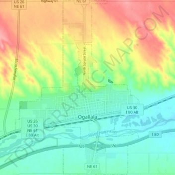
Name: Ogallala topographic map, elevation, terrain.

Location: Ogallala, Keith County, Nebraska, 69153, United States (41.10541 -101.75101 41.16374 -101.69366)

Average elevation: 3,307 ft

Minimum elevation: 3,179 ft

Maximum elevation: 3,507 ft

Keith County trails, hiking, mountain biking, running and outdoor activities

Other topographic maps

Click on a map to view its topography, its elevation and its terrain.

Lemoyne

United States > Nebraska > Keith County

Average elevation: 3,337 ft

Belmar

United States > Nebraska > Keith County

Average elevation: 3,333 ft

Gear up for your next adventure:

🥾Hiking Shoes - Durable and comfortable shoes for trail hiking
🛠️Outdoor Gear Repair Kit - Essential tools to fix gear on the trail
🧭Orienteering Set - Complete compass and map reading kit
🪶Multi‑Purpose Knife - Useful blade for camp and trail
🦶Carbon Trekking Poles - Reduce knee impact on steep descents with ultra-light poles

As an Amazon Associate, this site earns from qualifying purchases at no extra cost to you.