Geolocate

Steinkjer topographic map

Click on the map to display elevation.

About this map
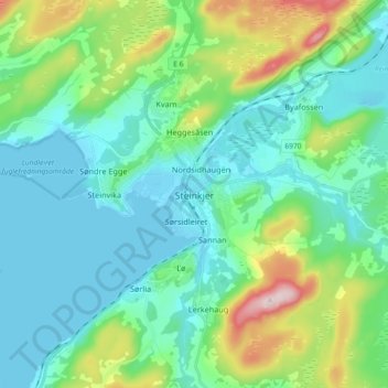
Name: Steinkjer topographic map, elevation, terrain.

Location: Steinkjer, Trøndelag, 7714, Norway (63.97518 11.45566 64.05518 11.53566)

Average elevation: 243 ft

Minimum elevation: -3 ft

Maximum elevation: 1,099 ft

Other topographic maps

Click on a map to view its topography, its elevation and its terrain.

Stjørdal

Norway > Trøndelag

Average elevation: 1,030 ft

Inderøy

Norway > Trøndelag

Average elevation: 509 ft

Selbu

Norway > Trøndelag

Average elevation: 1,801 ft

Verdal

Norway > Trøndelag

Average elevation: 1,319 ft

Austra

Norway > Trøndelag

Average elevation: 318 ft

Gear up for your next adventure:

🪶Camping Sleeping Pad - Comfortable sleeping pad for backpacking
🧯Emergency Survival Kit - All‑in‑one survival essentials for the backcountry
🪑Portable Camp Table - Compact table for campsite meals
🌡️Portable Weather Meter - Track weather conditions on the trail
📦Gear Storage Bags - Organize and protect outdoor equipment

As an Amazon Associate, this site earns from qualifying purchases at no extra cost to you.