Geolocate

One Mile topographic map

Click on the map to display elevation.

About this map

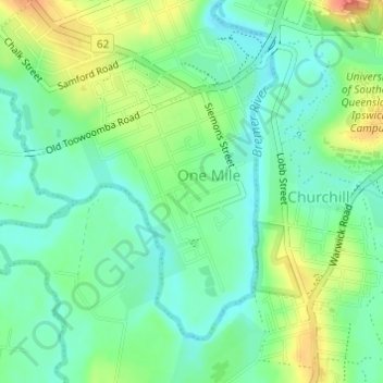
Name: One Mile topographic map, elevation, terrain.

Location: One Mile, Ipswich City, Queensland, Australia (-27.64510 152.72828 -27.62430 152.74780)

Average elevation: 89 ft

Minimum elevation: 26 ft

Maximum elevation: 200 ft

Other topographic maps

Click on a map to view its topography, its elevation and its terrain.

Stanton Cross

Australia > Queensland > Ipswich City

Average elevation: 92 ft

Mount Grey

Australia > Queensland > Ipswich City

Average elevation: 758 ft

Spring Mountain

Australia > Queensland > Ipswich City

Average elevation: 623 ft

White Rock

Australia > Queensland > Ipswich City

Average elevation: 374 ft

Gear up for your next adventure:

🩳Quick‑Dry Hiking Shorts - Comfortable and quick‑dry shorts for summer hiking
🥄Camping Utensil Set - Lightweight utensils for outdoor meals
🔦Powerful Headlamps - Ultra-bright hands-free lighting for night navigation
👟Men's Trail Runners - Lightweight footwear for fast-paced exploration and light hiking
🚗GPS Dash Cams - Record your scenic drives through mountain passes and canyons

As an Amazon Associate, this site earns from qualifying purchases at no extra cost to you.