
Make a donation
Gear up for your next adventure:
As an Amazon Associate, this site earns from qualifying purchases at no extra cost to you.
White Rock topographic map
Click on the map to display elevation.
Make a donation
Gear up for your next adventure:
As an Amazon Associate, this site earns from qualifying purchases at no extra cost to you.
About this map
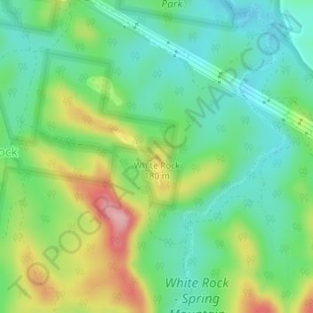
Name: White Rock topographic map, elevation, terrain.
Location: White Rock, Ipswich City, Queensland, 4301, Australia (-27.69479 152.86479 -27.69469 152.86489)
Average elevation: 374 ft
Minimum elevation: 203 ft
Maximum elevation: 696 ft
Make a donation
Gear up for your next adventure:
As an Amazon Associate, this site earns from qualifying purchases at no extra cost to you.
Other topographic maps
Click on a map to view its topography, its elevation and its terrain.
Make a donation
Gear up for your next adventure:
As an Amazon Associate, this site earns from qualifying purchases at no extra cost to you.
Flinders - Goolman Conservation Estate
Australia > Queensland > Ipswich City
Average elevation: 515 ft
Make a donation
Gear up for your next adventure:
As an Amazon Associate, this site earns from qualifying purchases at no extra cost to you.
Make a donation
Gear up for your next adventure:
As an Amazon Associate, this site earns from qualifying purchases at no extra cost to you.
Calvert
Australia > Queensland > Ipswich City
The Main Line railway passes through Calvert as does Western Creek, a tributary of the Bremer River. A 2014 flood mapping study of the Western Creek catchment has provided more reliable flood information to residents and landowners. In the northern extents elevations rise to 340 metres above sea level around…
Average elevation: 315 ft
Make a donation
Gear up for your next adventure:
As an Amazon Associate, this site earns from qualifying purchases at no extra cost to you.