
Make a donation
Gear up for your next adventure:
As an Amazon Associate, this site earns from qualifying purchases at no extra cost to you.
Georgenberg topographic map
Click on the map to display elevation.
Make a donation
Gear up for your next adventure:
As an Amazon Associate, this site earns from qualifying purchases at no extra cost to you.
Georgenberg
Um 1530 wurden in den Tarnowitzer Höhen im Herzogtum Beuthen reiche Silber- und Bleilagerstätten entdeckt. Auf den Fluren von Groß Zyglin (Żyglin) wurde nahe der Straße von Tarnowitz nach Tschenstochau ein Bergwerk errichtet, bei dem eine Ansiedlung der Bergleute entstand.
Make a donation
Gear up for your next adventure:
As an Amazon Associate, this site earns from qualifying purchases at no extra cost to you.
About this map
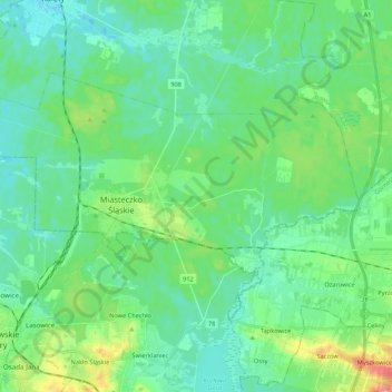
Name: Georgenberg topographic map, elevation, terrain.
Average elevation: 948 ft
Minimum elevation: 850 ft
Maximum elevation: 1,112 ft
Make a donation
Gear up for your next adventure:
As an Amazon Associate, this site earns from qualifying purchases at no extra cost to you.
Other topographic maps
Click on a map to view its topography, its elevation and its terrain.