Geolocate

Oakdale topographic map

Click on the map to display elevation.

About this map

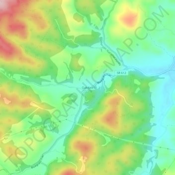
Name: Oakdale topographic map, elevation, terrain.

Location: Oakdale, Rockbridge County, Virginia, United States (37.71624 -79.61671 37.75624 -79.57671)

Average elevation: 1,421 ft

Minimum elevation: 1,132 ft

Maximum elevation: 1,893 ft

Rockbridge County trails, hiking, mountain biking, running and outdoor activities

Other topographic maps

Click on a map to view its topography, its elevation and its terrain.

Glasgow

United States > Virginia > Rockbridge County

Average elevation: 932 ft

Hays Creek

United States > Virginia > Rockbridge County

Average elevation: 1,437 ft

Goshen

United States > Virginia > Rockbridge County

Average elevation: 1,549 ft

Gear up for your next adventure:

🧤Hiking Gloves - Protective gloves for rugged trails
🔦Powerful Headlamps - Ultra-bright hands-free lighting for night navigation
👖Convertible Hiking Pants - Versatile zip-off pants for changing altitudes and temperatures
🧭Pro Hiking Compasses - High-accuracy liquid-filled compasses for topographic orientation
📖Nature Tracking Books - Learn to track wildlife and terrain

As an Amazon Associate, this site earns from qualifying purchases at no extra cost to you.