
Make a donation
Gear up for your next adventure:
As an Amazon Associate, this site earns from qualifying purchases at no extra cost to you.
Barrowby topographic map
Click on the map to display elevation.
Make a donation
Gear up for your next adventure:
As an Amazon Associate, this site earns from qualifying purchases at no extra cost to you.
About this map
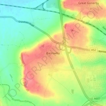
Name: Barrowby topographic map, elevation, terrain.
Average elevation: 253 ft
Minimum elevation: 131 ft
Maximum elevation: 390 ft
Make a donation
Gear up for your next adventure:
As an Amazon Associate, this site earns from qualifying purchases at no extra cost to you.
Other topographic maps
Click on a map to view its topography, its elevation and its terrain.
Deeping St. James
United Kingdom > England > Lincolnshire > South Kesteven > Frognall
Average elevation: 16 ft
Make a donation
Gear up for your next adventure:
As an Amazon Associate, this site earns from qualifying purchases at no extra cost to you.
Carlton Scroop
United Kingdom > England > Lincolnshire > South Kesteven > Carlton Scroop
Average elevation: 210 ft
Make a donation
Gear up for your next adventure:
As an Amazon Associate, this site earns from qualifying purchases at no extra cost to you.
Make a donation
Gear up for your next adventure:
As an Amazon Associate, this site earns from qualifying purchases at no extra cost to you.
Witham on the Hill
United Kingdom > England > Lincolnshire > South Kesteven > Witham on the Hill
Average elevation: 148 ft
Uffington Park
United Kingdom > England > Lincolnshire > South Kesteven > Uffington
Average elevation: 98 ft
Make a donation
Gear up for your next adventure:
As an Amazon Associate, this site earns from qualifying purchases at no extra cost to you.
Make a donation
Gear up for your next adventure:
As an Amazon Associate, this site earns from qualifying purchases at no extra cost to you.
Woolsthorpe By Belvoir
United Kingdom > England > Lincolnshire > South Kesteven > Woolsthorpe-by-Belvoir
Average elevation: 243 ft
Allington
United Kingdom > England > Lincolnshire > South Kesteven > Allington
Average elevation: 121 ft
Little Haw Wood
United Kingdom > England > Lincolnshire > South Kesteven > Castle Bytham
Average elevation: 302 ft
Make a donation
Gear up for your next adventure:
As an Amazon Associate, this site earns from qualifying purchases at no extra cost to you.
Witham on the Hill
United Kingdom > England > Lincolnshire > South Kesteven > Witham on the Hill
Average elevation: 148 ft