
Westmount topographic map
Click on the map to display elevation.
About this map
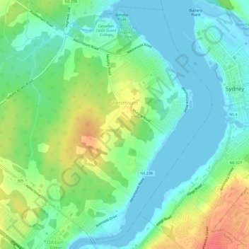
Name: Westmount topographic map, elevation, terrain.
Average elevation: 62 ft
Minimum elevation: -26 ft
Maximum elevation: 180 ft
Other topographic maps
Click on a map to view its topography, its elevation and its terrain.
Centreville
Canada > Nova Scotia > Cape Breton Regional Municipality > Sydney Mines
Average elevation: 39 ft
Margaret Boone Memorial Park
Canada > Nova Scotia > Cape Breton Regional Municipality > Dominion
Average elevation: 43 ft