
Make a donation
Gear up for your next adventure:
As an Amazon Associate, this site earns from qualifying purchases at no extra cost to you.
Cardwell Town topographic map
Click on the map to display elevation.
Make a donation
Gear up for your next adventure:
As an Amazon Associate, this site earns from qualifying purchases at no extra cost to you.
About this map
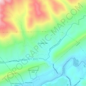
Name: Cardwell Town topographic map, elevation, terrain.
Location: Cardwell Town, Smyth County, Virginia, 24370, United States (36.88206 -81.79901 36.92206 -81.75901)
Average elevation: 2,415 ft
Minimum elevation: 1,677 ft
Maximum elevation: 3,993 ft
Smyth County trails, hiking, mountain biking, running and outdoor activities
Make a donation
Gear up for your next adventure:
As an Amazon Associate, this site earns from qualifying purchases at no extra cost to you.
Other topographic maps
Click on a map to view its topography, its elevation and its terrain.
Make a donation
Gear up for your next adventure:
As an Amazon Associate, this site earns from qualifying purchases at no extra cost to you.