
Make a donation
Gear up for your next adventure:
As an Amazon Associate, this site earns from qualifying purchases at no extra cost to you.
Dranouter topographic map
Click on the map to display elevation.
Make a donation
Gear up for your next adventure:
As an Amazon Associate, this site earns from qualifying purchases at no extra cost to you.
Dranouter
Dranouter ligt in Zandlemig Vlaanderen en het West-Vlaams Heuvelland. De dorpskom ligt op ongeveer 55 meter hoogte, en in het oosten liggen de Monteberg en de Kemmelberg, terwijl in het zuiden de Douvebeek stroomt.
Make a donation
Gear up for your next adventure:
As an Amazon Associate, this site earns from qualifying purchases at no extra cost to you.
About this map
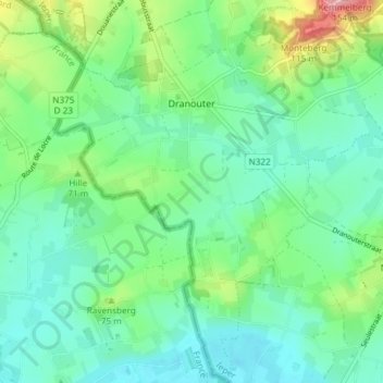
Name: Dranouter topographic map, elevation, terrain.
Location: Dranouter, Heuvelland, Ieper, West-Vlaanderen, 8951, België (50.73180 2.75651 50.77843 2.83090)
Average elevation: 164 ft
Minimum elevation: 46 ft
Maximum elevation: 502 ft
Make a donation
Gear up for your next adventure:
As an Amazon Associate, this site earns from qualifying purchases at no extra cost to you.
Other topographic maps
Click on a map to view its topography, its elevation and its terrain.