
Make a donation
Gear up for your next adventure:
As an Amazon Associate, this site earns from qualifying purchases at no extra cost to you.
De Klijte topographic map
Click on the map to display elevation.
Make a donation
Gear up for your next adventure:
As an Amazon Associate, this site earns from qualifying purchases at no extra cost to you.
About this map
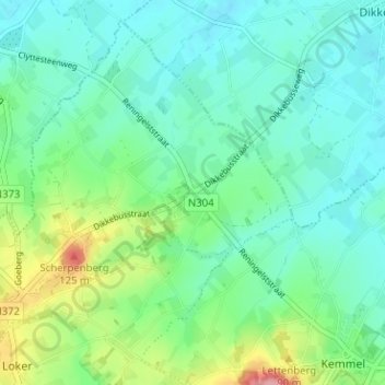
Name: De Klijte topographic map, elevation, terrain.
Location: De Klijte, Heuvelland, Ieper, West-Vlaanderen, 8956, België (50.78068 2.78116 50.82068 2.82116)
Average elevation: 167 ft
Minimum elevation: 75 ft
Maximum elevation: 436 ft
Make a donation
Gear up for your next adventure:
As an Amazon Associate, this site earns from qualifying purchases at no extra cost to you.
Other topographic maps
Click on a map to view its topography, its elevation and its terrain.
Nieuwkerke
België > West-Vlaanderen > Ieper > Heuvelland > Nieuwkerke
Nieuwkerke ligt in Zandlemig Vlaanderen en in het West-Vlaams Heuvelland op een hoogte van ongeveer 65 meter. Hier ligt de zuidelijke heuvelkam van het heuvelland met De Walletjes en Zwarte Molen (80 meter). Ten noorden van Nieuwkerke loopt de Douvebeek in oostelijke richting. Naar het zuiden toe neemt de…
Average elevation: 95 ft
Westouter
België > West-Vlaanderen > Ieper > Heuvelland
Westouter ligt in Zandlemig Vlaanderen en het West-Vlaams Heuvelland. De hoogte varieert tussen 35 en 143 meter. De belangrijkste heuvels zijn Rodeberg met het Hellegat, Zwarteberg, Scherpenberg en Vidaigneberg. De enige kabelbaan van Vlaanderen, de stoeltjeslift Cordoba, verbindt de Vidaigneberg en de…
Average elevation: 194 ft
Dranouter
België > West-Vlaanderen > Ieper > Heuvelland
Dranouter ligt in Zandlemig Vlaanderen en het West-Vlaams Heuvelland. De dorpskom ligt op ongeveer 55 meter hoogte, en in het oosten liggen de Monteberg en de Kemmelberg, terwijl in het zuiden de Douvebeek stroomt.
Average elevation: 164 ft