
Make a donation
Gear up for your next adventure:
As an Amazon Associate, this site earns from qualifying purchases at no extra cost to you.
Covilhã topographic map
Click on the map to display elevation.
Make a donation
Gear up for your next adventure:
As an Amazon Associate, this site earns from qualifying purchases at no extra cost to you.
Covilhã
The cold increases according to altitude, varying from higher temperatures in the lower parts of the municipality, to colder temperatures with frequent and sometimes abundant snowfalls during the cold months in the higher areas, such as Penhas da Saúde, above 1,500 meters of altitude, 9 km away from the highest point of mainland Portugal, the Torre Plateau. In the urban area of Covilhã snowfalls with accumulation are rare.
Make a donation
Gear up for your next adventure:
As an Amazon Associate, this site earns from qualifying purchases at no extra cost to you.
About this map
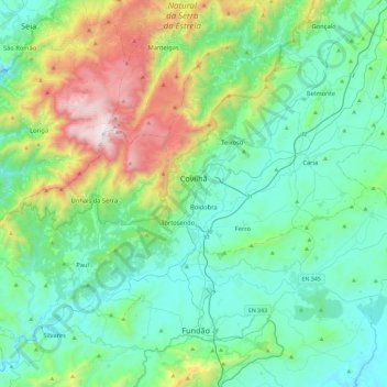
Name: Covilhã topographic map, elevation, terrain.
Location: Covilhã, Castelo Branco, Portugal (40.13004 -7.80904 40.40184 -7.34378)
Average elevation: 2,329 ft
Minimum elevation: 1,112 ft
Maximum elevation: 6,532 ft
Make a donation
Gear up for your next adventure:
As an Amazon Associate, this site earns from qualifying purchases at no extra cost to you.
Other topographic maps
Click on a map to view its topography, its elevation and its terrain.
Monte Gordo
Portugal > Castelo Branco > Castelo Branco > Santo André das Tojeiras
Average elevation: 935 ft
Make a donation
Gear up for your next adventure:
As an Amazon Associate, this site earns from qualifying purchases at no extra cost to you.
Make a donation
Gear up for your next adventure:
As an Amazon Associate, this site earns from qualifying purchases at no extra cost to you.
Inselberg de Monsanto
Portugal > Castelo Branco > Idanha-a-Nova > Adingeiro
Average elevation: 1,591 ft
Make a donation
Gear up for your next adventure:
As an Amazon Associate, this site earns from qualifying purchases at no extra cost to you.
Póvoa de Rio de Moinhos
Portugal > Castelo Branco > Póvoa de Rio de Moinhos e Cafede
Average elevation: 1,188 ft
Make a donation
Gear up for your next adventure:
As an Amazon Associate, this site earns from qualifying purchases at no extra cost to you.
Vale de Prazeres
Portugal > Castelo Branco > Vale de Prazeres e Mata da Rainha > Vale de Prazeres
Average elevation: 1,841 ft
Make a donation
Gear up for your next adventure:
As an Amazon Associate, this site earns from qualifying purchases at no extra cost to you.
Aldeia de João Pires
Portugal > Castelo Branco > Aldeia do Bispo, Águas e Aldeia de João Pires > Aldeia de João Pires
Average elevation: 1,476 ft
Make a donation
Gear up for your next adventure:
As an Amazon Associate, this site earns from qualifying purchases at no extra cost to you.
Poço do Forno Velho
Portugal > Castelo Branco > Covilhã > Cortes do Meio > Bouça
Average elevation: 2,936 ft