Geolocate

Watha topographic map

Click on the map to display elevation.

About this map

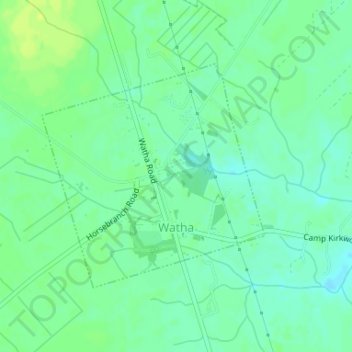
Name: Watha topographic map, elevation, terrain.

Location: Watha, Pender County, North Carolina, United States (34.63582 -77.97336 34.65303 -77.95254)

Average elevation: 56 ft

Minimum elevation: 33 ft

Maximum elevation: 82 ft

Pender County trails, hiking, mountain biking, running and outdoor activities

Other topographic maps

Click on a map to view its topography, its elevation and its terrain.

Willard

United States > North Carolina > Pender County

Average elevation: 52 ft

Currie

United States > North Carolina > Pender County

Average elevation: 30 ft

Surf City

United States > North Carolina > Pender County

Average elevation: 33 ft

Sunnyside

United States > North Carolina > Pender County

Average elevation: 56 ft

Shaken

United States > North Carolina > Pender County

Average elevation: 20 ft

Gear up for your next adventure:

🥾Men's Hiking Boots - Durable, waterproof footwear for rugged terrain and steep inclines
🥩Freeze-Dried Meals - Nutritious and lightweight food for remote expeditions
🎒Day Hiking Backpack - Lightweight backpack perfect for day trips and outdoor adventures
🩹Survival Bandages - High‑quality bandages for emergencies
📡Handheld GPS Device - Reliable handheld GPS for outdoor navigation

As an Amazon Associate, this site earns from qualifying purchases at no extra cost to you.