
Make a donation
Gear up for your next adventure:
As an Amazon Associate, this site earns from qualifying purchases at no extra cost to you.
Orinoco topographic map
Click on the map to display elevation.
Make a donation
Gear up for your next adventure:
As an Amazon Associate, this site earns from qualifying purchases at no extra cost to you.
About this map
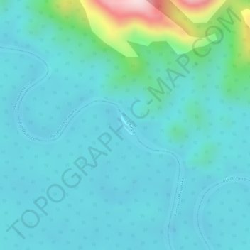
Name: Orinoco topographic map, elevation, terrain.
Average elevation: 669 ft
Minimum elevation: 479 ft
Maximum elevation: 1,601 ft
Make a donation
Gear up for your next adventure:
As an Amazon Associate, this site earns from qualifying purchases at no extra cost to you.
Other topographic maps
Click on a map to view its topography, its elevation and its terrain.
Cerro Delgado Chalbaud
Venezuela > Amazonas State > Municipio Autónomo Alto Orinoco
Average elevation: 3,058 ft
Alto Orinoco Municipality
Venezuela > Amazonas State > Alto Orinoco Municipality
Average elevation: 1,601 ft
Make a donation
Gear up for your next adventure:
As an Amazon Associate, this site earns from qualifying purchases at no extra cost to you.
Parroquia Alto Orinoco
Venezuela > Amazonas State > Alto Orinoco Municipality
Average elevation: 1,604 ft
Make a donation
Gear up for your next adventure:
As an Amazon Associate, this site earns from qualifying purchases at no extra cost to you.