
Make a donation
Gear up for your next adventure:
As an Amazon Associate, this site earns from qualifying purchases at no extra cost to you.
Delray Beach topographic map
Click on the map to display elevation.
Make a donation
Gear up for your next adventure:
As an Amazon Associate, this site earns from qualifying purchases at no extra cost to you.
Delray Beach
Delray Beach has hot and humid summers. High summertime temperatures range from 87–93 °F with low temperatures around 75–78 °F. Winters are warm, with a marked drier season. Ordinarily wintertime high temperatures are typically in the range of 74–83 °F and low temperatures 57–65 °F. However, when occasional cold fronts hit South Florida, daytime high temperatures may only reach the low or mid 60s (°F). Overnight lows during these brief periods can sink into the 40s. These cold fronts do not typically last more than a day or two and only occur several times each winter. Its near sea-level elevation, coastal location, position above the Tropic of Cancer, and proximity to the Gulf Stream shapes its climate. Hurricane season officially runs from June 1 through November 30, although hurricanes can develop outside those dates. The most likely time for hurricane activity is during the peak of the Cape Verde season, which is mid-August through the end of September. Delray Beach has received direct or near direct hits from hurricanes in 1903, 1906, 1928, 1947, 1949, 1964, 1965, 1979, 1992, 1999, 2004, and 2005.
Make a donation
Gear up for your next adventure:
As an Amazon Associate, this site earns from qualifying purchases at no extra cost to you.
About this map
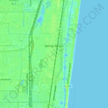
Name: Delray Beach topographic map, elevation, terrain.
Location: Delray Beach, Palm Beach County, Florida, United States (26.42053 -80.13026 26.49148 -80.05535)
Average elevation: 20 ft
Minimum elevation: 0 ft
Maximum elevation: 59 ft
Palm Beach County trails, hiking, mountain biking, running and outdoor activities
Make a donation
Gear up for your next adventure:
As an Amazon Associate, this site earns from qualifying purchases at no extra cost to you.
Other topographic maps
Click on a map to view its topography, its elevation and its terrain.
Make a donation
Gear up for your next adventure:
As an Amazon Associate, this site earns from qualifying purchases at no extra cost to you.
Make a donation
Gear up for your next adventure:
As an Amazon Associate, this site earns from qualifying purchases at no extra cost to you.
Make a donation
Gear up for your next adventure:
As an Amazon Associate, this site earns from qualifying purchases at no extra cost to you.
Make a donation
Gear up for your next adventure:
As an Amazon Associate, this site earns from qualifying purchases at no extra cost to you.
Delray Beach
United States > Florida > Palm Beach County > Delray Beach
Delray Beach has hot and humid summers. High summertime temperatures range from 87-93 °F with low temperatures around 75-78 °F. Winters are warm, with a marked drier season. Typical wintertime high temperatures are typically in the range of 74-83 °F and low temperatures 57-65 °F. However, when occasional…
Average elevation: 13 ft
Villages of Oriole
United States > Florida > Palm Beach County > Villages of Oriole
Average elevation: 30 ft
Make a donation
Gear up for your next adventure:
As an Amazon Associate, this site earns from qualifying purchases at no extra cost to you.
Palm Beach Lakes
United States > Florida > Palm Beach County > West Palm Beach
Average elevation: 26 ft
Blue Inlet
United States > Florida > Palm Beach County > Boca Raton > Blue Inlet
Average elevation: 13 ft
Oslo national park
United States > Florida > Palm Beach County > West Palm Beach
Average elevation: 30 ft
Make a donation
Gear up for your next adventure:
As an Amazon Associate, this site earns from qualifying purchases at no extra cost to you.