Geolocate

Marks Tey topographic map

Click on the map to display elevation.

About this map

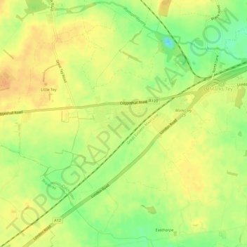
Name: Marks Tey topographic map, elevation, terrain.

Location: Marks Tey, Colchester, Essex, England, United Kingdom (51.85951 0.73950 51.88992 0.79512)

Average elevation: 131 ft

Minimum elevation: 62 ft

Maximum elevation: 171 ft

Other topographic maps

Click on a map to view its topography, its elevation and its terrain.

Berechurch

United Kingdom > England > Essex > Colchester

Average elevation: 92 ft

Layer-de-la-Haye

United Kingdom > England > Essex > Colchester

Average elevation: 95 ft

Wivenhoe Woods

United Kingdom > England > Essex > Colchester > Wivenhoe > Rowhedge

Average elevation: 59 ft

Boxted Cross

United Kingdom > England > Essex > Colchester > Boxted

Average elevation: 125 ft

Rowhedge

United Kingdom > England > Essex > Colchester

Average elevation: 66 ft

Birch Green

United Kingdom > England > Essex > Colchester

Average elevation: 115 ft

Messing

United Kingdom > England > Essex > Colchester

Average elevation: 148 ft

Salcott

United Kingdom > England > Essex > Colchester > Salcott

Average elevation: 46 ft

Dedham Vale

United Kingdom > England > Essex > Colchester > Dedham

Average elevation: 49 ft

Inworth

United Kingdom > England > Essex > Colchester

Average elevation: 151 ft

Gear up for your next adventure:

🏕️Family Camping Gear - Essentials for group camping trips
🥇GPS Hiking Watch - Multi‑sport GPS watch with navigation and trail tracking
🧭Outdoor Navigation Book - Learn advanced navigation skills
🧭Orienteering Set - Complete compass and map reading kit
📱Heavy-Duty Phone Cases - Drop-proof and waterproof protection for outdoor navigation

As an Amazon Associate, this site earns from qualifying purchases at no extra cost to you.