
Make a donation
Gear up for your next adventure:
As an Amazon Associate, this site earns from qualifying purchases at no extra cost to you.
Parsonsfield topographic map
Click on the map to display elevation.
Make a donation
Gear up for your next adventure:
As an Amazon Associate, this site earns from qualifying purchases at no extra cost to you.
Parsonsfield
The surface of Parsonsfield is quite broken, or more properly, rises into high swells. Ricker's Mountain, in the southwest, is the highest, it being not far from 1,600 feet (490 m) above the level of the sea. Cedar Mountain, in the center, comes up within one hundred feet of Ricker's, while Randall's Mountain in the east, may fall 100 feet (30 m) below Cedar. The Seminary varies but little from 1,200 feet (370 m) above sea level, while the average altitude of the town is estimated at 1,000 feet (300 m). After Parsonsfield Seminary burned in 1854, Bates College was founded as a replacement.
Make a donation
Gear up for your next adventure:
As an Amazon Associate, this site earns from qualifying purchases at no extra cost to you.
About this map
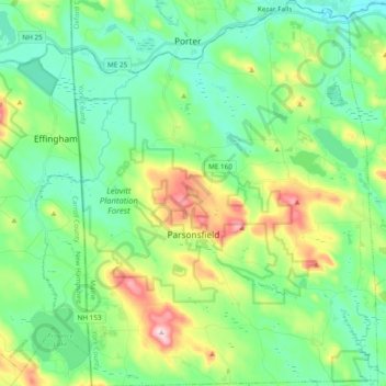
Name: Parsonsfield topographic map, elevation, terrain.
Location: Parsonsfield, York County, Maine, 04047, United States (43.67322 -70.98912 43.81086 -70.83809)
Average elevation: 571 ft
Minimum elevation: 292 ft
Maximum elevation: 1,286 ft
York County trails, hiking, mountain biking, running and outdoor activities
Make a donation
Gear up for your next adventure:
As an Amazon Associate, this site earns from qualifying purchases at no extra cost to you.
Other topographic maps
Click on a map to view its topography, its elevation and its terrain.
Make a donation
Gear up for your next adventure:
As an Amazon Associate, this site earns from qualifying purchases at no extra cost to you.
Make a donation
Gear up for your next adventure:
As an Amazon Associate, this site earns from qualifying purchases at no extra cost to you.