
Allenstown topographic map
Click on the map to display elevation.
About this map
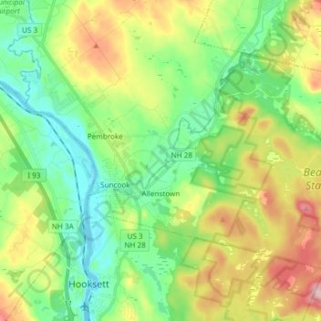
Name: Allenstown topographic map, elevation, terrain.
Location: Allenstown, Merrimack County, New Hampshire, United States (43.10204 -71.46635 43.17536 -71.31756)
Average elevation: 427 ft
Minimum elevation: 174 ft
Maximum elevation: 902 ft
Other topographic maps
Click on a map to view its topography, its elevation and its terrain.
Catamount Mountain
United States > New Hampshire > Merrimack County > Pittsfield
Average elevation: 922 ft
Kezer Seminary
United States > New Hampshire > Merrimack County > Canterbury
Average elevation: 633 ft
Shaker Village
United States > New Hampshire > Merrimack County > Canterbury
Average elevation: 673 ft
Rings Corner
United States > New Hampshire > Merrimack County > Pittsfield > Rings Corner
Average elevation: 623 ft