
Make a donation
Gear up for your next adventure:
As an Amazon Associate, this site earns from qualifying purchases at no extra cost to you.
Altlandsberg topographic map
Click on the map to display elevation.
Make a donation
Gear up for your next adventure:
As an Amazon Associate, this site earns from qualifying purchases at no extra cost to you.
Altlandsberg
Städte: Altlandsberg | Bad Freienwalde (Oder) | Müncheberg | Seelow | Strausberg | Wriezen. Gemeinden: Alt Tucheband | Beiersdorf-Freudenberg | Bleyen-Genschmar | Bliesdorf | Buckow (Märkische Schweiz) | Falkenberg | Falkenhagen (Mark) | Fichtenhöhe | Fredersdorf-Vogelsdorf | Garzau-Garzin | Golzow | Gusow-Platkow | Heckelberg-Brunow | Höhenland | Hoppegarten | Küstriner Vorland | Lebus | Letschin | Lietzen | Lindendorf | Märkische Höhe | Neuenhagen bei Berlin | Neuhardenberg | Neulewin | Neutrebbin | Oberbarnim | Oderaue | Petershagen/Eggersdorf | Podelzig | Prötzel | Rehfelde | Reichenow-Möglin | Reitwein | Rüdersdorf bei Berlin | Treplin | Vierlinden | Waldsieversdorf | Zechin | Zeschdorf
Make a donation
Gear up for your next adventure:
As an Amazon Associate, this site earns from qualifying purchases at no extra cost to you.
About this map
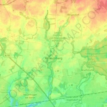
Name: Altlandsberg topographic map, elevation, terrain.
Location: Altlandsberg, Märkisch-Oderland, Brandenburg, Deutschland (52.53971 13.66866 52.59181 13.83211)
Average elevation: 210 ft
Minimum elevation: 128 ft
Maximum elevation: 302 ft
Make a donation
Gear up for your next adventure:
As an Amazon Associate, this site earns from qualifying purchases at no extra cost to you.
Other topographic maps
Click on a map to view its topography, its elevation and its terrain.
Bötzsee
Deutschland > Brandenburg > Märkisch-Oderland > Altlandsberg > Altlandsberg
Average elevation: 213 ft