
Make a donation
Gear up for your next adventure:
As an Amazon Associate, this site earns from qualifying purchases at no extra cost to you.
Bötzsee topographic map
Click on the map to display elevation.
Make a donation
Gear up for your next adventure:
As an Amazon Associate, this site earns from qualifying purchases at no extra cost to you.
About this map
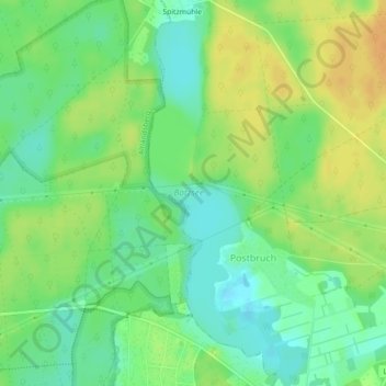
Name: Bötzsee topographic map, elevation, terrain.
Average elevation: 213 ft
Minimum elevation: 164 ft
Maximum elevation: 266 ft
Make a donation
Gear up for your next adventure:
As an Amazon Associate, this site earns from qualifying purchases at no extra cost to you.
Other topographic maps
Click on a map to view its topography, its elevation and its terrain.
Altlandsberg
Deutschland > Brandenburg > Märkisch-Oderland > Altlandsberg > Altlandsberg
Städte: Altlandsberg | Bad Freienwalde (Oder) | Müncheberg | Seelow | Strausberg | Wriezen. Gemeinden: Alt Tucheband | Beiersdorf-Freudenberg | Bleyen-Genschmar | Bliesdorf | Buckow (Märkische Schweiz) | Falkenberg | Falkenhagen (Mark) | Fichtenhöhe | Fredersdorf-Vogelsdorf | Garzau-Garzin | Golzow |…
Average elevation: 210 ft
Paulshof
Deutschland > Brandenburg > Märkisch-Oderland > Altlandsberg > Altlandsberg
Average elevation: 217 ft