
Make a donation
Gear up for your next adventure:
As an Amazon Associate, this site earns from qualifying purchases at no extra cost to you.
L'Épinay topographic map
Click on the map to display elevation.
Make a donation
Gear up for your next adventure:
As an Amazon Associate, this site earns from qualifying purchases at no extra cost to you.
About this map
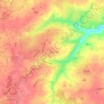
Name: L'Épinay topographic map, elevation, terrain.
Average elevation: 285 ft
Minimum elevation: 98 ft
Maximum elevation: 354 ft
Make a donation
Gear up for your next adventure:
As an Amazon Associate, this site earns from qualifying purchases at no extra cost to you.
Other topographic maps
Click on a map to view its topography, its elevation and its terrain.
49600
France > Pays de la Loire > Maine-et-Loire > Montrevault-sur-Èvre > La Pétraudière
Average elevation: 272 ft
Montrevault
France > Pays de la Loire > Maine-et-Loire > Montrevault-sur-Èvre
Average elevation: 220 ft
La Boissière-sur-Èvre
France > Pays de la Loire > Maine-et-Loire > Montrevault-sur-Èvre
Average elevation: 259 ft
Make a donation
Gear up for your next adventure:
As an Amazon Associate, this site earns from qualifying purchases at no extra cost to you.
Étang de la Gilière
France > Pays de la Loire > Maine-et-Loire > Montrevault-sur-Èvre
Average elevation: 354 ft
Saint-Pierre-Montlimart
France > Pays de la Loire > Maine-et-Loire > Montrevault-sur-Èvre
Average elevation: 253 ft
Saint-Rémy-en-Mauges
France > Pays de la Loire > Maine-et-Loire > Montrevault-sur-Èvre
Average elevation: 262 ft
Make a donation
Gear up for your next adventure:
As an Amazon Associate, this site earns from qualifying purchases at no extra cost to you.