
Make a donation
Gear up for your next adventure:
As an Amazon Associate, this site earns from qualifying purchases at no extra cost to you.
Le Fuilet topographic map
Click on the map to display elevation.
Make a donation
Gear up for your next adventure:
As an Amazon Associate, this site earns from qualifying purchases at no extra cost to you.
About this map
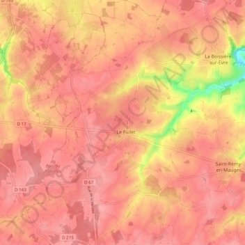
Name: Le Fuilet topographic map, elevation, terrain.
Average elevation: 292 ft
Minimum elevation: 56 ft
Maximum elevation: 361 ft
Make a donation
Gear up for your next adventure:
As an Amazon Associate, this site earns from qualifying purchases at no extra cost to you.
Other topographic maps
Click on a map to view its topography, its elevation and its terrain.
Chaudron-en-Mauges
France > Pays de la Loire > Maine-et-Loire > Montrevault-sur-Èvre
L'altitude de la commune varie de 25 à 146 mètres, et son territoire s'étend sur près de 26 km2 (2 571 hectares).
Average elevation: 266 ft
Saint-Rémy-en-Mauges
France > Pays de la Loire > Maine-et-Loire > Montrevault-sur-Èvre
Average elevation: 246 ft
Étang de la Gilière
France > Pays de la Loire > Maine-et-Loire > Montrevault-sur-Èvre
Average elevation: 354 ft
Make a donation
Gear up for your next adventure:
As an Amazon Associate, this site earns from qualifying purchases at no extra cost to you.
La Maison Neuve
France > Pays de la Loire > Maine-et-Loire > Montrevault-sur-Èvre
Average elevation: 220 ft