Geolocate

Lafferty topographic map

Click on the map to display elevation.

About this map

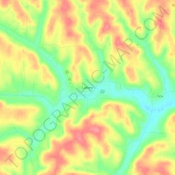
Name: Lafferty topographic map, elevation, terrain.

Location: Lafferty, Belmont County, Ohio, 43951, United States (40.09174 -81.03926 40.13174 -80.99926)

Average elevation: 1,129 ft

Minimum elevation: 988 ft

Maximum elevation: 1,253 ft

Belmont County trails, hiking, mountain biking, running and outdoor activities

Other topographic maps

Click on a map to view its topography, its elevation and its terrain.

Neffs

United States > Ohio > Belmont County > Neffs

Average elevation: 984 ft

Morristown

United States > Ohio > Belmont County

Average elevation: 1,227 ft

Flushing

United States > Ohio > Belmont County

Average elevation: 1,198 ft

Holloway

United States > Ohio > Belmont County

Average elevation: 1,027 ft

Brookside

United States > Ohio > Belmont County

Average elevation: 922 ft

Bridgeport

United States > Ohio > Belmont County

Average elevation: 801 ft

Bethesda

United States > Ohio > Belmont County

Average elevation: 1,234 ft

Belmont

United States > Ohio > Belmont County

Average elevation: 1,184 ft

Martins Ferry

United States > Ohio > Belmont County

Average elevation: 945 ft

Piedmont Lake

United States > Ohio > Belmont County

Average elevation: 1,053 ft

Yorkville

United States > Ohio > Belmont County

Average elevation: 840 ft

Powhatan Point

United States > Ohio > Belmont County

Average elevation: 791 ft

Shadyside

United States > Ohio > Belmont County

Average elevation: 804 ft

Gear up for your next adventure:

📦Gear Storage Bags - Organize and protect outdoor equipment
🔪Outdoor Multitools - Essential survival tools for gear repair and field use
Solar GPS Watches - Advanced multisport watches with built-in topographic maps
❄️Traction Cleats - Prevent slips on icy trails during winter hikes
⛑️Personal Locator Beacon - Safety beacon for emergencies

As an Amazon Associate, this site earns from qualifying purchases at no extra cost to you.