Geolocate

Hazleton topographic map

Click on the map to display elevation.

About this map

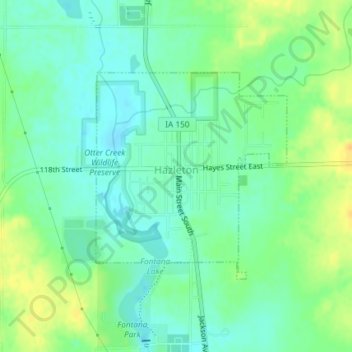
Name: Hazleton topographic map, elevation, terrain.

Location: Hazleton, Buchanan County, Iowa, United States (42.60893 -91.91424 42.62479 -91.89431)

Average elevation: 1,010 ft

Minimum elevation: 971 ft

Maximum elevation: 1,066 ft

Buchanan County trails, hiking, mountain biking, running and outdoor activities

Other topographic maps

Click on a map to view its topography, its elevation and its terrain.

Littleton

United States > Iowa > Buchanan County

Average elevation: 951 ft

Gear up for your next adventure:

🧣Merino Neck Gaiters - Multi-functional headwear for wind and sun protection
🔋Solar Power Banks - Keep your GPS and phone charged in remote wilderness areas
GPS Sports Watch - GPS watch for running, hiking and training
🧤Tactile Hiking Gloves - Keep hands warm while operating GPS and smartphone screens
🧢Sun Protection Hats - Wide-brimmed and UPF-rated hats for high-altitude sun safety

As an Amazon Associate, this site earns from qualifying purchases at no extra cost to you.