Geolocate

Littleton topographic map

Click on the map to display elevation.

About this map

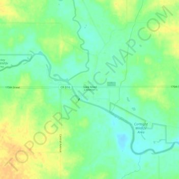
Name: Littleton topographic map, elevation, terrain.

Location: Littleton, Buchanan County, Iowa, United States (42.51273 -92.04468 42.55273 -92.00468)

Average elevation: 951 ft

Minimum elevation: 906 ft

Maximum elevation: 1,004 ft

Buchanan County trails, hiking, mountain biking, running and outdoor activities

Other topographic maps

Click on a map to view its topography, its elevation and its terrain.

Lamont

United States > Iowa > Buchanan County

Average elevation: 1,056 ft

Quasqueton

United States > Iowa > Buchanan County

Average elevation: 906 ft

Stanley

United States > Iowa > Buchanan County

Average elevation: 1,122 ft

Hazleton

United States > Iowa > Buchanan County

Average elevation: 1,010 ft

Fairbank

United States > Iowa > Buchanan County

Average elevation: 988 ft

Brandon

United States > Iowa > Buchanan County

Average elevation: 869 ft

Aurora

United States > Iowa > Buchanan County

Average elevation: 1,119 ft

Winthrop

United States > Iowa > Buchanan County

Average elevation: 1,033 ft

Rowley

United States > Iowa > Buchanan County

Average elevation: 971 ft

Gear up for your next adventure:

📱Heavy-Duty Phone Cases - Drop-proof and waterproof protection for outdoor navigation
🧯Portable Fire Pit - Compact fire pit for camping spots
🔊Portable Camp Speaker - Music and alerts at camp
🪶Multi‑Purpose Knife - Useful blade for camp and trail
Solar GPS Watches - Advanced multisport watches with built-in topographic maps

As an Amazon Associate, this site earns from qualifying purchases at no extra cost to you.