
Gedling topographic map
Click on the map to display elevation.
About this map
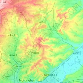
Name: Gedling topographic map, elevation, terrain.
Location: Gedling, Nottinghamshire, England, United Kingdom (52.94816 -1.23129 53.10394 -1.00709)
Average elevation: 253 ft
Minimum elevation: 46 ft
Maximum elevation: 640 ft
Other topographic maps
Click on a map to view its topography, its elevation and its terrain.
Hucknall
United Kingdom > England > Nottinghamshire > Ashfield
Hucknall Airfield, built in 1916, became RAF Hucknall. From 1927, Rolls-Royce began using the airfield for flight tests. During World War II, the aerodrome at Hucknall launched the first flight of a P-51 Mustang fitted with a Rolls-Royce Merlin Engine. The Merlin, replacing the earlier Allison V-1710 engine,…
Average elevation: 341 ft
Mansfield
United Kingdom > England > Nottinghamshire > Mansfield > Mansfield
Average elevation: 420 ft