Geolocate

Winrock topographic map

Click on the map to display elevation.

About this map

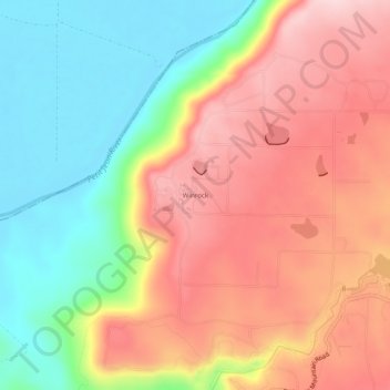
Name: Winrock topographic map, elevation, terrain.

Location: Winrock, Conway County, Arkansas, United States (35.11814 -92.96378 35.15814 -92.92378)

Average elevation: 722 ft

Minimum elevation: 289 ft

Maximum elevation: 1,145 ft

Conway County trails, hiking, mountain biking, running and outdoor activities

Other topographic maps

Click on a map to view its topography, its elevation and its terrain.

Menifee

United States > Arkansas > Conway County

Average elevation: 318 ft

Oppelo

United States > Arkansas > Conway County

Average elevation: 318 ft

Plumerville

United States > Arkansas > Conway County

Average elevation: 348 ft

Morrilton

United States > Arkansas > Conway County

Average elevation: 338 ft

Gear up for your next adventure:

📦Dry Bags Set - Waterproof storage for electronics and clothes
🧭Hiking Compass - Precision compass for reliable navigation in the wilderness
🏔️Mountain Trail Maps - High‑detail maps for popular peaks
🧥Men's Rain Shells - Premium waterproof and breathable jackets for mountain weather
🛏️Cold Weather Sleeping Bag - Warm sleeping bag for cold conditions

As an Amazon Associate, this site earns from qualifying purchases at no extra cost to you.