Geolocate

Monkey Run topographic map

Click on the map to display elevation.

About this map

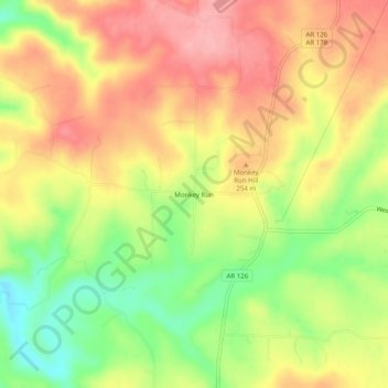
Name: Monkey Run topographic map, elevation, terrain.

Location: Monkey Run, Baxter County, Arkansas, 72651, United States (36.32535 -92.49988 36.36535 -92.45988)

Average elevation: 768 ft

Minimum elevation: 548 ft

Maximum elevation: 945 ft

Baxter County trails, hiking, mountain biking, running and outdoor activities

Other topographic maps

Click on a map to view its topography, its elevation and its terrain.

Norfork Lake

United States > Arkansas > Baxter County

Average elevation: 741 ft

Gassville

United States > Arkansas > Baxter County

Average elevation: 656 ft

Salesville

United States > Arkansas > Baxter County

Average elevation: 558 ft

Big Flat

United States > Arkansas > Baxter County

Average elevation: 1,161 ft

Briarcliff

United States > Arkansas > Baxter County

Average elevation: 774 ft

Gear up for your next adventure:

🌄Hiking Binoculars - Compact binoculars for scenic views and trail spotting
🧭Pro Hiking Compasses - High-accuracy liquid-filled compasses for topographic orientation
🔦LED Headlamp - Bright and durable LED headlamp for night navigation
🛏️Cold Weather Sleeping Bag - Warm sleeping bag for cold conditions
🕶️GPS Smartphone Mount - Secure mount for phone navigation

As an Amazon Associate, this site earns from qualifying purchases at no extra cost to you.