Geolocate

Vienna topographic map

Click on the map to display elevation.

About this map

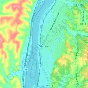
Name: Vienna topographic map, elevation, terrain.

Location: Vienna, Wood County, West Virginia, United States (39.29602 -81.55644 39.34854 -81.50730)

Average elevation: 702 ft

Minimum elevation: 584 ft

Maximum elevation: 984 ft

Wood County trails, hiking, mountain biking, running and outdoor activities

Other topographic maps

Click on a map to view its topography, its elevation and its terrain.

Deerwalk

United States > West Virginia > Wood County

Average elevation: 925 ft

Belleville

United States > West Virginia > Wood County

Average elevation: 679 ft

Lee Creek

United States > West Virginia > Wood County

Average elevation: 673 ft

Slate

United States > West Virginia > Wood County

Average elevation: 738 ft

Ogden

United States > West Virginia > Wood County

Average elevation: 817 ft

Gear up for your next adventure:

🗃️Trail First Aid Kit - Essential kit for outdoor injuries and emergencies
🔪Outdoor Multitools - Essential survival tools for gear repair and field use
🧢Sun Protection Hats - Wide-brimmed and UPF-rated hats for high-altitude sun safety
🧺Microfiber Travel Towels - Compact and fast-drying towels for trail use
🪶Camping Sleeping Pad - Comfortable sleeping pad for backpacking

As an Amazon Associate, this site earns from qualifying purchases at no extra cost to you.