Geolocate

Ogden topographic map

Click on the map to display elevation.

About this map

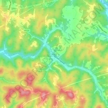
Name: Ogden topographic map, elevation, terrain.

Location: Ogden, Wood County, West Virginia, 26184, United States (39.28174 -81.42206 39.32174 -81.38206)

Average elevation: 817 ft

Minimum elevation: 617 ft

Maximum elevation: 1,040 ft

Other topographic maps

Click on a map to view its topography, its elevation and its terrain.

Vienna

United States > West Virginia > Wood County

Average elevation: 702 ft

Parkersburg

United States > West Virginia > Wood County

Average elevation: 702 ft

Williamstown

United States > West Virginia > Wood County

Average elevation: 646 ft

Washington

United States > West Virginia > Wood County

Average elevation: 682 ft

Vienna

United States > West Virginia > Wood County

Average elevation: 702 ft

Parkersburg

United States > West Virginia > Wood County

Average elevation: 699 ft

Washington

United States > West Virginia > Wood County

Average elevation: 682 ft

Parkersburg

United States > West Virginia > Wood County

Average elevation: 702 ft

Gear up for your next adventure:

😴Insulated Sleeping Pads - Compact and warm pads for high-elevation camping
🎒Trekking Poles - Sturdy poles for balance and stability on rough terrain
🗃️Trail First Aid Kit - Essential kit for outdoor injuries and emergencies
🛠️Outdoor Gear Repair Kit - Essential tools to fix gear on the trail
📡GPS Antenna Upgrade - Enhance GPS reception in remote terrain

As an Amazon Associate, this site earns from qualifying purchases at no extra cost to you.