Geolocate

Turin topographic map

Click on the map to display elevation.

About this map

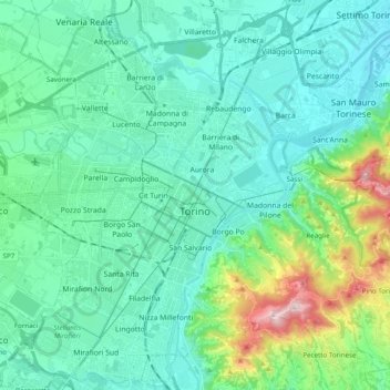
Name: Turin topographic map, elevation, terrain.

Location: Turin, Torino, Piedmont, Italy (45.00679 7.57783 45.14022 7.77334)

Average elevation: 948 ft

Minimum elevation: 633 ft

Maximum elevation: 2,339 ft

Other topographic maps

Click on a map to view its topography, its elevation and its terrain.

Turin

Italy > Piedmont > Turin

Average elevation: 968 ft

Sportinia

Italy > Piedmont > Turin > Sauze d'Oulx

Average elevation: 6,611 ft

Turin

Italy > Piedmont > Turin

Average elevation: 968 ft

Pratobotrile

Italy > Piedmont > Turin > Condove

Average elevation: 3,665 ft

Turin

Italy > Piedmont > Turin

Average elevation: 968 ft

Rivetto

Italy > Piedmont > Turin > San Giorio di Susa

Average elevation: 1,913 ft

Magnoletto

Italy > Piedmont > Turin > Condove

Average elevation: 2,293 ft

Suppo

Italy > Piedmont > Turin > Rubiana

Average elevation: 4,429 ft

Tornetti

Italy > Piedmont > Turin > Viù

Average elevation: 4,373 ft

Baio Dora

Italy > Piedmont > Turin

Average elevation: 1,621 ft

Famolasco

Italy > Piedmont > Turin

Average elevation: 1,667 ft

Morelli

Italy > Piedmont > Turin > Gravere

Average elevation: 2,575 ft

La Cialma

Italy > Piedmont > Turin > Locana

Average elevation: 5,594 ft

Belvedere

Italy > Piedmont > Turin > Borgiallo

Average elevation: 2,405 ft

Gear up for your next adventure:

📚USA Hiking Guide Books - Top trail guides and map books
💧Water Filtration Bottles - Safely drink from streams and lakes while exploring
🥘Titanium Cookware - Durable, featherlight pots and pans for backpacking
🌐World Map Poster - Decorative world maps with topographic info
🔌Solar Panel Charger - Charge gear sustainably outdoors

As an Amazon Associate, this site earns from qualifying purchases at no extra cost to you.