
Turin topographic map
Click on the map to display elevation.
About this map
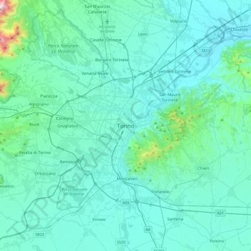
Name: Turin topographic map, elevation, terrain.
Location: Turin, Piedmont, 10100, Italy (44.90776 7.52249 45.22776 7.84249)
Average elevation: 968 ft
Minimum elevation: 568 ft
Maximum elevation: 4,974 ft
Other topographic maps
Click on a map to view its topography, its elevation and its terrain.
Sestriere
An elite track and field athletics meeting was held annually in Sestriere from 1988 to 1996, and again in 2004. The advantage of its high altitude in sprinting and jumping events held out hope of world records, with sponsor Ferrari offering a car as a bonus. One record was set, in the men's pole vault by…
Average elevation: 6,955 ft
Parco Generale Carlo Alberto Dalla Chiesa
Italy > Piedmont > Turin > Collegno
Average elevation: 974 ft
Ronco Canavese
The village sits at about a 956-meter elevation, while its territory ranges from deep valley floors (around 774 meters) up to high alpine summits of over 3,400 meters. This dramatic terrain is part of the Graian Alps near the Gran Paradiso massif, featuring waterfalls, glacial cirques, and pristine mountain…
Average elevation: 6,083 ft
Sestriere
An elite track and field athletics meeting was held annually in Sestriere from 1988 to 1996, and again in 2004. The advantage of its high altitude in sprinting and jumping events held out hope of world records, with sponsor Ferrari offering a car as a bonus. One record was set, in the men's pole vault by…
Average elevation: 6,955 ft
Ivrea
Ivrea is situated at an altitude of approximately 267 meters above sea level, not far from the entrance to the Aosta Valley. It is crossed by the Dora Baltea river, a tributary of the Po, and is located in an area shaped by a large Pleistocene glacier, which over time transported numerous debris that formed a…
Average elevation: 797 ft