Geolocate

Herrnhut topographic map

Click on the map to display elevation.

About this map

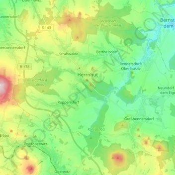
Name: Herrnhut topographic map, elevation, terrain.

Location: Herrnhut, Görlitz, Saxony, 02747, Germany (50.96602 14.67265 51.05172 14.83824)

Average elevation: 1,099 ft

Minimum elevation: 745 ft

Maximum elevation: 1,857 ft

Other topographic maps

Click on a map to view its topography, its elevation and its terrain.

Elster

Germany > Saxony > Görlitz > Zittau

Average elevation: 1,470 ft

Rohne - Rowno

Germany > Saxony > Görlitz

Average elevation: 417 ft

Schlauroth

Germany > Saxony > Görlitz > Görlitz

Average elevation: 787 ft

Mamut

Germany > Saxony > Görlitz > Jonsdorf

Average elevation: 1,703 ft

Bruder Klaus

Germany > Saxony > Görlitz > Jonsdorf

Average elevation: 1,716 ft

Rosenbach

Germany > Saxony > Görlitz > Rosenbach > Rosenbach

Average elevation: 951 ft

Gear up for your next adventure:

🎒Day Hiking Backpack - Lightweight backpack perfect for day trips and outdoor adventures
📶Satellite Messenger - Communication device off‑grid
🧣Merino Neck Gaiters - Multi-functional headwear for wind and sun protection
🧭Orienteering Set - Complete compass and map reading kit
🔦LED Headlamp - Bright and durable LED headlamp for night navigation

As an Amazon Associate, this site earns from qualifying purchases at no extra cost to you.