Geolocate

Rohne - Rowno topographic map

Click on the map to display elevation.

About this map

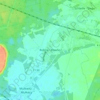
Name: Rohne - Rowno topographic map, elevation, terrain.

Location: Rohne - Rowno, Schleife - Slepo, Schleife, Görlitz, Saxony, 02959, Germany (51.50791 14.49318 51.54791 14.53318)

Average elevation: 417 ft

Minimum elevation: 387 ft

Maximum elevation: 502 ft

Other topographic maps

Click on a map to view its topography, its elevation and its terrain.

Löbau

Germany > Saxony > Görlitz

Average elevation: 896 ft

Weißkeißel – Wuskidź

Germany > Saxony > Görlitz

Average elevation: 433 ft

Boxberg/O.L. - Hamor

Germany > Saxony > Görlitz

Average elevation: 433 ft

Zittau

Germany > Saxony > Görlitz

Average elevation: 1,060 ft

Herrnhut

Germany > Saxony > Görlitz

Average elevation: 1,099 ft

Großschönau

Germany > Saxony > Görlitz

Average elevation: 1,332 ft

Görlitz

Germany > Saxony > Görlitz

Average elevation: 732 ft

Ostritz

Germany > Saxony > Görlitz

Average elevation: 876 ft

Görlitz

Germany > Saxony > Görlitz

Average elevation: 732 ft

Neusalza-Spremberg

Germany > Saxony > Görlitz > Neusalza-Spremberg > Sonneberg

Average elevation: 1,165 ft

Bad Muskau - Mužakow

Germany > Saxony > Görlitz

Average elevation: 427 ft

Görlitz

Germany > Saxony > Görlitz

Average elevation: 732 ft

Gear up for your next adventure:

🌐World Map Poster - Decorative world maps with topographic info
🧭Compass with Lanyard - Easy‑carry compass for navigation
🧭GPS Watch Accessories - Bands and chargers for GPS watches
🧦Merino Wool Socks - Moisture-wicking, blister-preventing socks for long treks
📦Gear Storage Bags - Organize and protect outdoor equipment

As an Amazon Associate, this site earns from qualifying purchases at no extra cost to you.