
Make a donation
Gear up for your next adventure:
As an Amazon Associate, this site earns from qualifying purchases at no extra cost to you.
La Luz topographic map
Click on the map to display elevation.
Make a donation
Gear up for your next adventure:
As an Amazon Associate, this site earns from qualifying purchases at no extra cost to you.
La Luz
The largest employer in the surrounding area is Holloman Air Force Base. La Luz itself is largely residential and agricultural in land use but a small market is located on the state maintained road that connects the village to Highway 70. La Luz has long been known for the many fruits that are grown in the area including figs, apricots, plums and peaches. Apples, cherries, and pears are grown in the higher elevations in the canyon areas to the east of the village. The surrounding area also has a number of vineyards and pistachio groves. A number of artists also reside in the area.
Make a donation
Gear up for your next adventure:
As an Amazon Associate, this site earns from qualifying purchases at no extra cost to you.
About this map
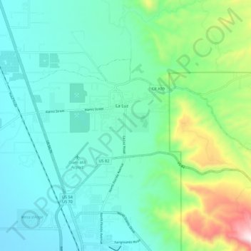
Name: La Luz topographic map, elevation, terrain.
Location: La Luz, Otero County, New Mexico, 88337, United States (32.94534 -105.98488 32.99428 -105.87564)
Average elevation: 4,879 ft
Minimum elevation: 4,318 ft
Maximum elevation: 6,867 ft
Otero County trails, hiking, mountain biking, running and outdoor activities
Make a donation
Gear up for your next adventure:
As an Amazon Associate, this site earns from qualifying purchases at no extra cost to you.
Other topographic maps
Click on a map to view its topography, its elevation and its terrain.
Sunspot
United States > New Mexico > Otero County
Sunspot is an unincorporated community in the Sacramento Mountains in the Lincoln National Forest in Otero County, New Mexico, United States, about 18 miles (29 km) south of Cloudcroft. Its elevation is 9,186 feet (2,800 m). The Sunspot Solar Observatory and Apache Point Observatory are located in Sunspot in…
Average elevation: 8,615 ft
High Rolls
United States > New Mexico > Otero County
The first official use of the High Rolls name was in 1901, when the post office was moved from Fresnal (Wooten) to High Rolls. The name, which was sometimes spelled as one word, Highrolls, supposedly came from the shape and elevation of the area as compared to the sharper peaks higher up.
Average elevation: 6,680 ft
Make a donation
Gear up for your next adventure:
As an Amazon Associate, this site earns from qualifying purchases at no extra cost to you.
Chihuahuan Desert
United States > New Mexico > Otero County
There are several larger mountain ranges in the Chihuahan Desert, including the Sierra Madre, the Sierra del Carmen, the Organ Mountains, the Franklin Mountains, the Sacramento Mountains, the Chisos Mountains, the Guadalupe Mountains, and the Davis Mountains. These create "sky islands" of cooler, wetter,…
Average elevation: 4,006 ft
Sunspot
United States > New Mexico > Otero County
The origins of Sunspot as a Solar Observatory date back to the sudden increased interest of solar physics to the US military during the Second World War. In 1940, the High Altitude Observatory (HAO) was established in 1940 in Climax, Colorado, by Walter Orr Roberts and Donald Menzel. It was associated with…
Average elevation: 8,615 ft
Cloudcroft
United States > New Mexico > Otero County > Cloudcroft
Cloudcroft is a village in Otero County, New Mexico, United States, and is located within the Lincoln National Forest. The population was 674 at the 2010 census. Despite being located in an otherwise arid region, its high elevation (8,676 feet (2,644 m); one of the highest in the U.S.) allows for a mild summer…
Average elevation: 8,648 ft