
Mayhill topographic map
Click on the map to display elevation.
About this map
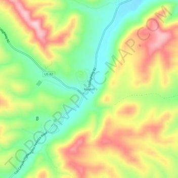
Name: Mayhill topographic map, elevation, terrain.
Location: Mayhill, Otero County, New Mexico, United States (32.86954 -105.49804 32.90954 -105.45804)
Average elevation: 6,903 ft
Minimum elevation: 6,476 ft
Maximum elevation: 7,398 ft
Otero County trails, hiking, mountain biking, running and outdoor activities
Other topographic maps
Click on a map to view its topography, its elevation and its terrain.
Alamogordo
United States > New Mexico > Otero County
As of 2010, Alamogordo had a total area of 19.3 square miles (50.0 km2), all of it land. The city is located at an elevation of 4,336 feet (1,322 m) on the western flank of the Sacramento Mountains and on the eastern edge of the Tularosa Basin. It lies within the Rio Grande rift and in the northernmost part of…
Average elevation: 4,970 ft
Cloudcroft
United States > New Mexico > Otero County
Cloudcroft is a village in Otero County, New Mexico, United States, and is located within the Lincoln National Forest. The population was 674 at the 2010 census. Despite being located in an otherwise arid region, its high elevation (8,676 feet (2,644 m); one of the highest in the U.S.) allows for a mild summer…
Average elevation: 8,671 ft
La Luz
United States > New Mexico > Otero County
The largest employer in the surrounding area is Holloman Air Force Base. La Luz itself is largely residential and agricultural in land use but a small market is located on the state maintained road that connects the village to Highway 70. La Luz has long been known for the many fruits that are grown in the…
Average elevation: 4,879 ft
Timberon
United States > New Mexico > Otero County
Timberon is located at 32°37′54″N 105°41′32″W / 32.63167°N 105.69222°W / 32.63167; -105.69222 (32.631675, -105.692254). Timberon is located in a forested valley, known as Sacramento Canyon, on the southern slopes of the Sacramento Mountains. The Sacramento Creek, an intermittent creek,…
Average elevation: 7,156 ft
White Sands National Park
United States > New Mexico > Otero County
The first US Army exploration of south-central New Mexico was led by a party of topographical engineering officers in 1849. They passed west of the San Andres Mountains and Organ Mountains. A lieutenant was dispatched east across the basin with a scouting party to map a potential military wagon route to the…
Average elevation: 3,983 ft
Alamogordo
United States > New Mexico > Otero County
As of 2010, Alamogordo had a total area of 19.3 square miles (50.0 km2), all of it land. The city is located at an elevation of 4,336 feet (1,322 m) on the western flank of the Sacramento Mountains and on the eastern edge of the Tularosa Basin. It lies within the Rio Grande rift and in the northernmost part of…
Average elevation: 4,682 ft
Timberon
United States > New Mexico > Otero County
Timberon is located in a forested valley, known as Sacramento Canyon, on the southern slopes of the Sacramento Mountains. The Sacramento Creek, an intermittent creek, flows southeast through the valley. The community extends up several crosscutting canyons including Arkansas Canyon, Graveyard Canyon and…
Average elevation: 7,274 ft
White Sands National Park
United States > New Mexico > Otero County
The first US Army exploration of south-central New Mexico was led by a party of topographical engineering officers in 1849. They passed west of the San Andres Mountains and Organ Mountains. A lieutenant was dispatched east across the basin with a scouting party to map a potential military wagon route to the…
Average elevation: 3,983 ft
Cloudcroft
United States > New Mexico > Otero County
Cloudcroft is a village in Otero County, New Mexico, United States, and is located within the Lincoln National Forest. The population was 674 at the 2010 census. Despite being located in an otherwise arid region, its high elevation (8,676 feet (2,644 m) allows for a mild summer and forested surroundings that…
Average elevation: 8,671 ft
Alamogordo
United States > New Mexico > Otero County
As of 2010, Alamogordo had a total area of 19.3 square miles (50.0 km2), all land. The city is located at an elevation of 4,330 feet (1,320 m) on the western flank of the Sacramento Mountains and on the eastern edge of the Tularosa Basin. It lies within the Rio Grande rift and in the northernmost part of the…
Average elevation: 4,682 ft
Cloudcroft
United States > New Mexico > Otero County
Its high elevation of 8,676 feet (2,644 m) allows for a mild summer, and the forested mountains make it a tourist attraction for the surrounding deserts. Tourism is the primary economy of the village.
Average elevation: 8,671 ft
La Luz
United States > New Mexico > Otero County
The largest employer in the surrounding area is Holloman Air Force Base. La Luz itself is largely residential and agricultural in land use but a small market is located on the state maintained road that connects the village to Highway 70. La Luz has long been known for the many fruits that are grown in the…
Average elevation: 4,879 ft