
Make a donation
Gear up for your next adventure:
As an Amazon Associate, this site earns from qualifying purchases at no extra cost to you.
Seine-et-Marne topographic map
Click on the map to display elevation.
Make a donation
Gear up for your next adventure:
As an Amazon Associate, this site earns from qualifying purchases at no extra cost to you.
About this map
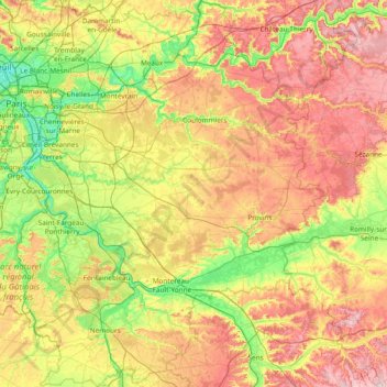
Name: Seine-et-Marne topographic map, elevation, terrain.
Location: Seine-et-Marne, Ile-de-France, Metropolitan France, France (48.12015 2.39233 49.11789 3.55922)
Average elevation: 404 ft
Minimum elevation: 92 ft
Maximum elevation: 922 ft
Make a donation
Gear up for your next adventure:
As an Amazon Associate, this site earns from qualifying purchases at no extra cost to you.
Other topographic maps
Click on a map to view its topography, its elevation and its terrain.
Paris Basin
France > Ile-de-France > Essonne > Bièvres
The landscape is one of very broad valleys (flood plains), modest watershed hills and well-drained plateaux of comparatively little altitude. In the south-east and east the plain of Champagne and the Seuil de Bourgogne (Threshold of Burgundy) differential erosion of the strata has left low scarps with the dip…
Average elevation: 413 ft
Make a donation
Gear up for your next adventure:
As an Amazon Associate, this site earns from qualifying purchases at no extra cost to you.
Make a donation
Gear up for your next adventure:
As an Amazon Associate, this site earns from qualifying purchases at no extra cost to you.
Le Champtier des Fourneaux
France > Ile-de-France > Yvelines > Dampierre-en-Yvelines
Average elevation: 469 ft
Make a donation
Gear up for your next adventure:
As an Amazon Associate, this site earns from qualifying purchases at no extra cost to you.
Parc de l'Abbaye du Lys
France > Ile-de-France > Seine-et-Marne > Dammarie-les-Lys
Average elevation: 217 ft
Make a donation
Gear up for your next adventure:
As an Amazon Associate, this site earns from qualifying purchases at no extra cost to you.
Résidence Parc de Béarn
France > Ile-de-France > Hauts-de-Seine > Saint-Cloud
Average elevation: 233 ft
Parc de Villette
France > Ile-de-France > Val-d'Oise > Condécourt > Villette
Average elevation: 282 ft
Make a donation
Gear up for your next adventure:
As an Amazon Associate, this site earns from qualifying purchases at no extra cost to you.
Make a donation
Gear up for your next adventure:
As an Amazon Associate, this site earns from qualifying purchases at no extra cost to you.
Val des Quatre Pignons
France > Ile-de-France > Yvelines > Beynes > Val des Quatre Pignons
Average elevation: 302 ft
Noisy-le-Grand
France > Ile-de-France > Seine-Saint-Denis > Noisy-le-Grand > Noisy-le-Grand
Average elevation: 230 ft
Make a donation
Gear up for your next adventure:
As an Amazon Associate, this site earns from qualifying purchases at no extra cost to you.
Mazagran
France > Ile-de-France > Seine-et-Marne > Saint-Denis-lès-Rebais > Mazagran
Average elevation: 486 ft
Parc de Billancourt
France > Ile-de-France > Hauts-de-Seine > Boulogne-Billancourt
Average elevation: 190 ft
Val Saint-Olaf
France > Ile-de-France > Hauts-de-Seine > Chaville > Val Saint-Olaf
Average elevation: 420 ft
Make a donation
Gear up for your next adventure:
As an Amazon Associate, this site earns from qualifying purchases at no extra cost to you.
Make a donation
Gear up for your next adventure:
As an Amazon Associate, this site earns from qualifying purchases at no extra cost to you.