Geolocate

Wallington topographic map

Click on the map to display elevation.

About this map

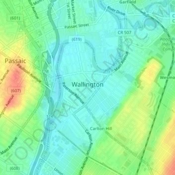
Name: Wallington topographic map, elevation, terrain.

Location: Wallington, Bergen County, New Jersey, 07057, United States (40.84150 -74.12007 40.86378 -74.09630)

Average elevation: 52 ft

Minimum elevation: 0 ft

Maximum elevation: 157 ft

Other topographic maps

Click on a map to view its topography, its elevation and its terrain.

Ridgewood

United States > New Jersey > Bergen County

Average elevation: 184 ft

Darlington

United States > New Jersey > Bergen County > Mahwah

Average elevation: 423 ft

Drag Hill

United States > New Jersey > Bergen County > Mahwah

Average elevation: 827 ft

Stag Hill

United States > New Jersey > Bergen County > Mahwah

Average elevation: 669 ft

Green Hill

United States > New Jersey > Bergen County > Mahwah

Average elevation: 574 ft

Fardale

United States > New Jersey > Bergen County > Mahwah

Average elevation: 407 ft

Cragmere

United States > New Jersey > Bergen County > Mahwah

Average elevation: 446 ft

Teterboro

United States > New Jersey > Bergen County > Teterboro

Average elevation: 39 ft

Westwood

United States > New Jersey > Bergen County > Westwood > Westwood

Average elevation: 102 ft

Glen Rock

United States > New Jersey > Bergen County > Glen Rock > Glen Rock

Average elevation: 171 ft

Hillsdale

United States > New Jersey > Bergen County > Hillsdale > Hillsdale

Average elevation: 131 ft

Gear up for your next adventure:

🪶LED Camping Lantern - Bright lantern for camp lighting
🧦Merino Wool Socks - Moisture-wicking, blister-preventing socks for long treks
🎒Day Hiking Backpack - Lightweight backpack perfect for day trips and outdoor adventures
🎁Geography Themed Gifts - Unique gift ideas for map lovers and geography enthusiasts
🛌Ultralight Sleeping Bags - Compact down bags for cold nights in the wilderness

As an Amazon Associate, this site earns from qualifying purchases at no extra cost to you.