
Make a donation
Gear up for your next adventure:
As an Amazon Associate, this site earns from qualifying purchases at no extra cost to you.
Alexânia topographic map
Click on the map to display elevation.
Make a donation
Gear up for your next adventure:
As an Amazon Associate, this site earns from qualifying purchases at no extra cost to you.
Alexânia
Com advento de Brasília, as condições de desenvolvimento comercial, imobiliário e industrial despertaram o interesse geral para a formação do núcleo urbano, ás margens da BR-060 entre Anápolis e a nova capital, numa posição privilegiada, topograficamente, além do excelente clima da região.
Make a donation
Gear up for your next adventure:
As an Amazon Associate, this site earns from qualifying purchases at no extra cost to you.
About this map
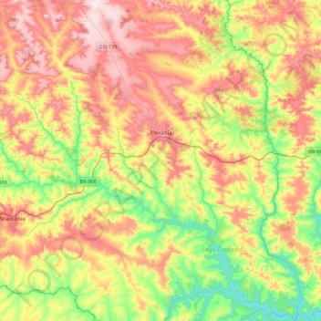
Name: Alexânia topographic map, elevation, terrain.
Average elevation: 3,156 ft
Minimum elevation: 2,612 ft
Maximum elevation: 3,780 ft
Make a donation
Gear up for your next adventure:
As an Amazon Associate, this site earns from qualifying purchases at no extra cost to you.
Other topographic maps
Click on a map to view its topography, its elevation and its terrain.
Corumbá IV
Brasil > Goiás > Região Integrada de Desenvolvimento do Distrito Federal e Entorno > Luziânia
Average elevation: 2,720 ft
São Gabriel de Goiás
Brasil > Goiás > Região Integrada de Desenvolvimento do Distrito Federal e Entorno > Planaltina
Average elevation: 3,960 ft
Goianópolis/ Malhador
Brasil > Goiás > Região Integrada de Desenvolvimento do Distrito Federal e Entorno > Pirenópolis
Average elevation: 2,421 ft
Santa Terezinha
Brasil > Goiás > Região Integrada de Desenvolvimento do Distrito Federal e Entorno > Pirenópolis
Average elevation: 2,438 ft
Make a donation
Gear up for your next adventure:
As an Amazon Associate, this site earns from qualifying purchases at no extra cost to you.
Planalmira
Brasil > Goiás > Região Integrada de Desenvolvimento do Distrito Federal e Entorno > Abadiânia
Average elevation: 3,619 ft
Morro
Brasil > Goiás > Região Integrada de Desenvolvimento do Distrito Federal e Entorno > Pirenópolis
Average elevation: 2,628 ft
Olhos D'Água
Brasil > Goiás > Região Integrada de Desenvolvimento do Distrito Federal e Entorno > Alexânia
Average elevation: 3,399 ft
Área de proteção ambiental
Brasil > Goiás > Região Integrada de Desenvolvimento do Distrito Federal e Entorno > Santo Antônio do Descoberto
Average elevation: 2,982 ft
Make a donation
Gear up for your next adventure:
As an Amazon Associate, this site earns from qualifying purchases at no extra cost to you.
Moinho Velho
Brasil > Goiás > Região Integrada de Desenvolvimento do Distrito Federal e Entorno > Pirenópolis > Meia Lua
Average elevation: 2,812 ft
Palmeiras
Brasil > Goiás > Região Integrada de Desenvolvimento do Distrito Federal e Entorno > Água Fria de Goiás
Average elevation: 3,720 ft
Taboquinha
Brasil > Goiás > Região Integrada de Desenvolvimento do Distrito Federal e Entorno > Padre Bernardo > Taboquinha
Average elevation: 2,477 ft
Serra Geral
Brasil > Goiás > Região Integrada de Desenvolvimento do Distrito Federal e Entorno > Vila Boa
Average elevation: 2,700 ft
Make a donation
Gear up for your next adventure:
As an Amazon Associate, this site earns from qualifying purchases at no extra cost to you.
Formosa
Brasil > Goiás > Região Integrada de Desenvolvimento do Distrito Federal e Entorno > Formosa
Average elevation: 3,022 ft
Cachoeira dos Dragões
Brasil > Goiás > Região Integrada de Desenvolvimento do Distrito Federal e Entorno > Pirenópolis
Average elevation: 3,415 ft
Salto do Itiquira
Brasil > Goiás > Região Integrada de Desenvolvimento do Distrito Federal e Entorno > Formosa
Average elevation: 3,028 ft
Córrego dos Macacos
Brasil > Goiás > Região Integrada de Desenvolvimento do Distrito Federal e Entorno > Cocalzinho de Goiás
Average elevation: 3,258 ft
Make a donation
Gear up for your next adventure:
As an Amazon Associate, this site earns from qualifying purchases at no extra cost to you.
Morro Grande
Brasil > Goiás > Região Integrada de Desenvolvimento do Distrito Federal e Entorno > Pirenópolis
Average elevation: 3,261 ft
Fagundes
Brasil > Goiás > Região Integrada de Desenvolvimento do Distrito Federal e Entorno > Pirenópolis
Average elevation: 3,123 ft
Morro do Frota
Brasil > Goiás > Região Integrada de Desenvolvimento do Distrito Federal e Entorno > Pirenópolis
Average elevation: 2,835 ft
Água Fria
Brasil > Goiás > Região Integrada de Desenvolvimento do Distrito Federal e Entorno > Pirenópolis
Average elevation: 3,114 ft
Make a donation
Gear up for your next adventure:
As an Amazon Associate, this site earns from qualifying purchases at no extra cost to you.
Caieras
Brasil > Goiás > Região Integrada de Desenvolvimento do Distrito Federal e Entorno > Pirenópolis
Average elevation: 2,484 ft
Monte Alto
Brasil > Goiás > Região Integrada de Desenvolvimento do Distrito Federal e Entorno > Padre Bernardo
Average elevation: 3,983 ft
Paiol Velho
Brasil > Goiás > Região Integrada de Desenvolvimento do Distrito Federal e Entorno > Pirenópolis
Average elevation: 2,395 ft
Pirenópolis
Brasil > Goiás > Região Integrada de Desenvolvimento do Distrito Federal e Entorno > Pirenópolis > Pirenópolis
Average elevation: 2,779 ft
Make a donation
Gear up for your next adventure:
As an Amazon Associate, this site earns from qualifying purchases at no extra cost to you.
Macoã
Brasil > Goiás > Região Integrada de Desenvolvimento do Distrito Federal e Entorno > Pirenópolis > Macoã
Average elevation: 3,409 ft
Praça São Vidente
Brasil > Goiás > Região Integrada de Desenvolvimento do Distrito Federal e Entorno > Formosa
Average elevation: 3,012 ft
Cocalzinho
Brasil > Goiás > Região Integrada de Desenvolvimento do Distrito Federal e Entorno > Cocalzinho de Goiás
Average elevation: 3,694 ft
Santa Teresa
Brasil > Goiás > Região Integrada de Desenvolvimento do Distrito Federal e Entorno > Formosa
Average elevation: 2,959 ft
Make a donation
Gear up for your next adventure:
As an Amazon Associate, this site earns from qualifying purchases at no extra cost to you.
Serra Miguel Inácio
Brasil > Goiás > Região Integrada de Desenvolvimento do Distrito Federal e Entorno > Padre Bernardo
Average elevation: 3,435 ft
Jaranápolis/ Três Ranchos
Brasil > Goiás > Região Integrada de Desenvolvimento do Distrito Federal e Entorno > Pirenópolis
Average elevation: 2,313 ft
Condominio Bom Jesus II
Brasil > Goiás > Região Integrada de Desenvolvimento do Distrito Federal e Entorno > Pirenópolis
Average elevation: 2,592 ft