
Make a donation
Gear up for your next adventure:
As an Amazon Associate, this site earns from qualifying purchases at no extra cost to you.
Akron topographic map
Click on the map to display elevation.
Make a donation
Gear up for your next adventure:
As an Amazon Associate, this site earns from qualifying purchases at no extra cost to you.
About this map
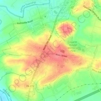
Name: Akron topographic map, elevation, terrain.
Location: Akron, Lancaster County, Pennsylvania, United States (40.14535 -76.21914 40.16993 -76.18632)
Average elevation: 413 ft
Minimum elevation: 289 ft
Maximum elevation: 541 ft
Lancaster County trails, hiking, mountain biking, running and outdoor activities
Make a donation
Gear up for your next adventure:
As an Amazon Associate, this site earns from qualifying purchases at no extra cost to you.
Other topographic maps
Click on a map to view its topography, its elevation and its terrain.
Ronks
United States > Pennsylvania > Lancaster County > East Lampeter Township
Average elevation: 377 ft
East Earl
United States > Pennsylvania > Lancaster County > East Earl Township
Average elevation: 541 ft
Hahnstown
United States > Pennsylvania > Lancaster County > Ephrata Township
Average elevation: 423 ft
Make a donation
Gear up for your next adventure:
As an Amazon Associate, this site earns from qualifying purchases at no extra cost to you.
Schoeneck
United States > Pennsylvania > Lancaster County > West Cocalico Township
Average elevation: 515 ft
Conestoga
United States > Pennsylvania > Lancaster County > Conestoga Township
Average elevation: 387 ft
Make a donation
Gear up for your next adventure:
As an Amazon Associate, this site earns from qualifying purchases at no extra cost to you.
Eagle Rock
United States > Pennsylvania > Lancaster County > Elizabeth Township
Average elevation: 633 ft
Chickies Rock
United States > Pennsylvania > Lancaster County > West Hempfield Township
Average elevation: 348 ft
Make a donation
Gear up for your next adventure:
As an Amazon Associate, this site earns from qualifying purchases at no extra cost to you.
Salunga
United States > Pennsylvania > Lancaster County > East Hempfield Township
Average elevation: 387 ft
Fertility
United States > Pennsylvania > Lancaster County > East Lampeter Township
Average elevation: 361 ft
Glen Moore
United States > Pennsylvania > Lancaster County > Manheim Township
Average elevation: 358 ft
Make a donation
Gear up for your next adventure:
As an Amazon Associate, this site earns from qualifying purchases at no extra cost to you.
Indian Rocks
United States > Pennsylvania > Lancaster County > East Cocalico Township
Average elevation: 528 ft
Blainsport
United States > Pennsylvania > Lancaster County > West Cocalico Township
Average elevation: 571 ft
Make a donation
Gear up for your next adventure:
As an Amazon Associate, this site earns from qualifying purchases at no extra cost to you.
Make a donation
Gear up for your next adventure:
As an Amazon Associate, this site earns from qualifying purchases at no extra cost to you.